

Latest Weather Blog
Saturday Morning Forecast
Related Story
Plenty of dry time, but those afternoon showers are not going anywhere just yet.
THE FORECAST
Today & Tonight: Mostly sunny skies will be hanging around for most of the morning hours. Cloud cover begins to build into the area as temperature rise into the low 90s. Plenty of moisture plus warm temperatures are the perfect recipe for a quick afternoon shower. These showers will be brief in and out but I wouldn't rule out a heavy down pour or frequent lightning as they roll through. Showers will begin to fizzle out quickly leaving plenty of dry time for any of your Saturday night plans. Cloud cover and humidity will be sticking around into the overnight hours as temperatures fall into the mid-70s.
Up Next: Sunday starts the new drying trend. Waking up to mostly clear skies but still on the sticky side. Throughout the day temperatures will warm closer to the average 93° mark. Afternoon showers will still be possible but not nearly as abundant as what we saw this past week. There will be plenty of dry time during the day and in the evening hours. Overnight temperatures will cool into the mid-70s and some light cloud cover will linger into the early morning hours. The change in the wet pattern is thanks to an area of lower pressure in the western Gulf of Mexico. This area is no threat to us, in fact it is helping our forecast. Monday will be the driest day of the week. Most people will stay completely dry. With the lack in showers and cloud cover temperatures will climb into the low-to-mid 90s across the area. Overnight temperatures fall back into the mid-70s. The drier pattern repeats for Tuesday. Click here to see the 7-day forecast.
Don’t let sneaky showers catch you off guard this weekend Hour-by-hour weather tracking is available for your location on the WBRZ WX App on your Apple or Android device. Follow WBRZ Weather on Facebook and Twitter for even more weather updates and unique weather insight from the whole team!
In the Tropics:
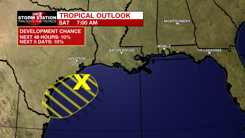
Northwestern Gulf of Mexico:
A weak low pressure area located over the northwestern Gulf of
Mexico is producing disorganized shower and thunderstorm activity.
Only slight development of this system is possible while it moves
west-southwestward at 5 to 10 mph and approaches the Texas coast
later today and tonight, then moves inland over southern Texas on
Sunday. Regardless of development, locally heavy rains are possible
along portions of the Texas coast through the weekend. For more
information about the potential for heavy rainfall, please see
products issued by your local National Weather Service office and
the Weather Prediction Center. The reconnaissance aircraft mission
scheduled for later today has been canceled.
* Formation chance through 48 hours...low...10 percent.
* Formation chance through 5 days...low...10 percent.
News
