

Latest Weather Blog
Friday PM Forecast: One more warm day, staring down near-freezing temps next week
The stretch of warm, muggy weather is almost over. An Arctic cold front is closing in and could bring the season’s first freeze to many areas next week. Use the weekend to make any final preparations.
Tonight & Tomorrow: Though the night will begin on a mostly clear note, low clouds will develop late as the muggy air mass hangs on. A more widespread, denser fog could form overnight, so be extra cautious if traveling early ahead of any weekend plans. Expect morning lows to settle roughly 15° above average, in the mid-60s. Low clouds and fog may linger through mid-to-late morning, but sunshine will poke out by afternoon. Highs will reach the low to mid-80s. Pockets of warmth could spark a brief, spotty shower for a select few — but very little rain is expected during the day. Saturday will be the last day with the warm and muggy feel.
Up Next: A strong cold front will barrel into the Capital Area late Saturday, into early Sunday. While there may be a thin stripe of showers just ahead of the front, they still appear insignificant. The bigger impact will be the immediate drop in temperatures and the subsequent increase in wind speeds. Highs on Sunday will struggle to rebound to 70°, which should occur around midday. Temperatures will then fall through the afternoon as a northerly wind at 10-20 mph drives an Arctic chill toward the coast.

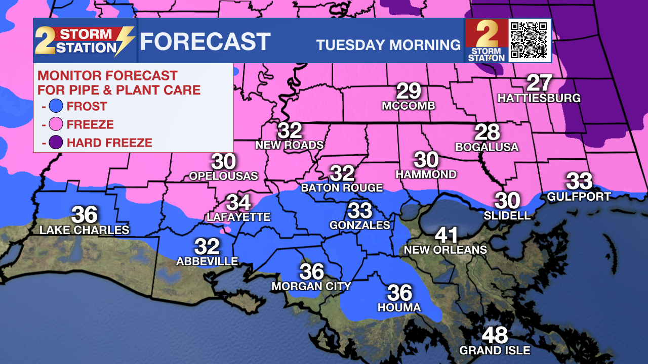
Lows will drop into the upper 30s around Baton Rouge Monday morning, with areas north of the city likely dipping into the mid-30s. Afternoon highs will remain in the 50s despite full sunshine. The coldest temperatures arrive Tuesday morning as the mercury drops to near freezing in Baton Rouge. Frost will be likely across most areas, with a light freeze possible as far south as I-10 and I-12. Use the weekend to take necessary precautions to protect sensitive plants and ensure pets have access to warmth. Also, take the time to disconnect garden hoses and disable sprinkler systems.
This brief winter chill won’t last long; temperatures will begin a warming trend on Veterans’ Day. Each day through the rest of the week, a few more degrees will be added to both highs and lows. By the week’s end, highs will reach the 70s with lows in the 50s.
Trending News
The Tropics: For the Gulf, Caribbean, and Atlantic, all is quiet. No new tropical development is expected over the next seven days.
Get the latest 7-day forecast and real-time weather updates HERE.
Watch live news HERE.
— Meteorologist Malcolm Byron
The Storm Station is here for you, on every platform. Your weather updates can be found on News 2, wbrz.com, and the WBRZ WX App on your Apple or Android device. Follow WBRZ Weather on Facebook and X for even more weather updates while you are on the go.
More News
