

Latest Weather Blog
Friday PM Forecast: Sunshine wins the weekend; rising rivers prompting alerts
A calm, comfortable, and dry spring forecast is expected through the weekend. Little change is expected to the local weather next week, but the Storm Station will be keeping a closer eye on the rising Mississippi River around that time.
Tonight & Tomorrow: The northwest wind that kicked up after an early cold front passage will relax into the evening. That, plus a clear sky will allow for a relatively cool night. Most will wake up to temperatures in the upper-40s on Saturday. Despite needing an extra layer or two early on, sunshine will warm things up quickly. Wind will be less of a factor, so there will be less turbulence to redistribute heat in the lower atmosphere. The net result will be a slightly cooler afternoon, but still quite pleasant—look for a high in the mid-70s. There will be no weather worries on Saturday.
Up Next: Another crisp morning is expected on Sunday with a low around the 50° mark. But daytime highs will trend warmer, rising into the low-80s. That runs a few degrees above average for mid-April. With little humidity and a slight south breeze, there will also be no weather worries on Sunday.
High pressure generally sticks around into next week, reinforcing the nice weather. The only hiccup will be a weak frontal passage on Tuesday. Even so, moisture will be limited. A spotty shower is possible at best on Tuesday, but more than likely most will only notice additional clouds. The front will have little effect on temperatures. Each day will feature a high in the upper-70s to low-80s with mild overnight lows in the 50s and 60s. In essence, the gorgeous spring weather continues — ideal for enjoying fresh air without sweating it out or getting rained on.
River Flooding: The National Weather Service has issued a RIVER FLOOD WARNING for the Mississippi River at Red River Landing until further notice. A RIVER FLOOD WARNING will go into effect late Monday for the Mississippi River at Baton Rouge.
Trending News
• At Red River Landing, flood stage is at 48 feet. Minor flooding is forecast by Friday evening. Moderate flooding is expected with a crest near 57 feet on April 23. Around these levels, Angola farmland on the left bank begins taking on water. Caution is urged when walking near riverbanks.
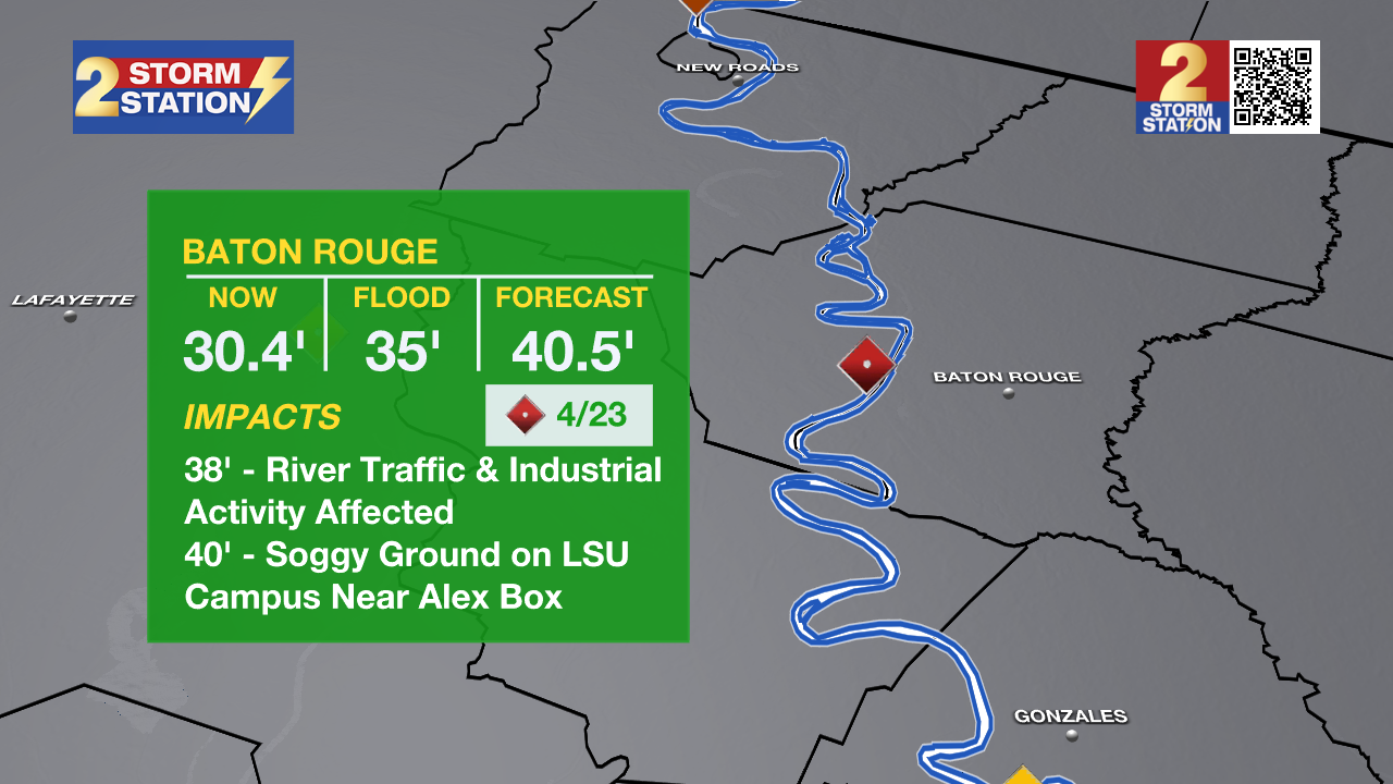
• At Baton Rouge, flood stage is 35 feet. Minor flooding is forecast to begin early Tuesday, cresting just above major flood stage on April 23 with a height of 40.5 feet. Levels will fall below flood stage around May 2. Around these levels, the grounds of the older part of Louisiana State University's campus become soggy. This includes the area around the Veterinary Medicine building, the Veterinary Medicine Annex, and Alex Box Stadium. Levees protect the city of Baton Rouge and the main LSU campus at this level. Caution is urged when walking near riverbanks.
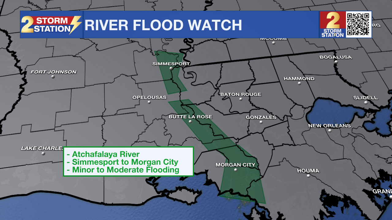
The National Weather Service has issued a RIVER FLOOD WATCH for the Atchafalaya River at Simmesport, Butte La Rose, and Morgan City until further notice.
• At Simmesport, flood stage of 40 feet may be reached by April 24. There will be flooding of areas inside the levees of the Atchafalaya Floodway and considerable flooding in the backwater storage area in Avoyelles Parish.
• At Butte La Rose, flood stage of 20 feet may be reached by April 24. Minor flooding of the nearby areas could occur.
• At Morgan City, flood stage of 6 feet may be reached by April 19. Moderate flooding at 7 feet is forecast by April 23. At 7 feet, buildings at the foot of Ann Street on the river side of the flood wall will flood as water overtops the Rio Oil Company dock. Buildings on the river side of the Berwick floodwall will flood. River traffic restrictions will be strictly enforced. In addition, backwater flooding could potentially impact portions of areas around Lake Palourde and Stephensville.
Get the latest 7-day forecast and real-time weather updates HERE.
Watch live news HERE.
-- Meteorologist Malcolm Byron
The Storm Station is here for you, on every platform. Your weather updates can be found on News 2, wbrz.com, and the WBRZ WX App on your Apple or Android device. Follow WBRZ Weather on Facebook and X for even more weather updates while you are on the go.
More News
