

Latest Weather Blog
LATEST: Tropical Storm Bertha turning west; Extreme Heat Warning posted for the area
UPDATE: Tropical Storm Bertha strengthened on Tuesday morning, packing maximum sustained winds of 60 mph on the southeast side of the system. On approach to the Louisiana coast, Bertha is expected to weaken due to hostile atmospheric conditions and land interaction. Isolated downpours have already started as of lunchtime Tuesday, associated with a developing rainband attached to Tropical Storm Bertha. Thankfully, impacts to the local area look rather low. Skip ahead to The Tropics section below for a full breakdown.
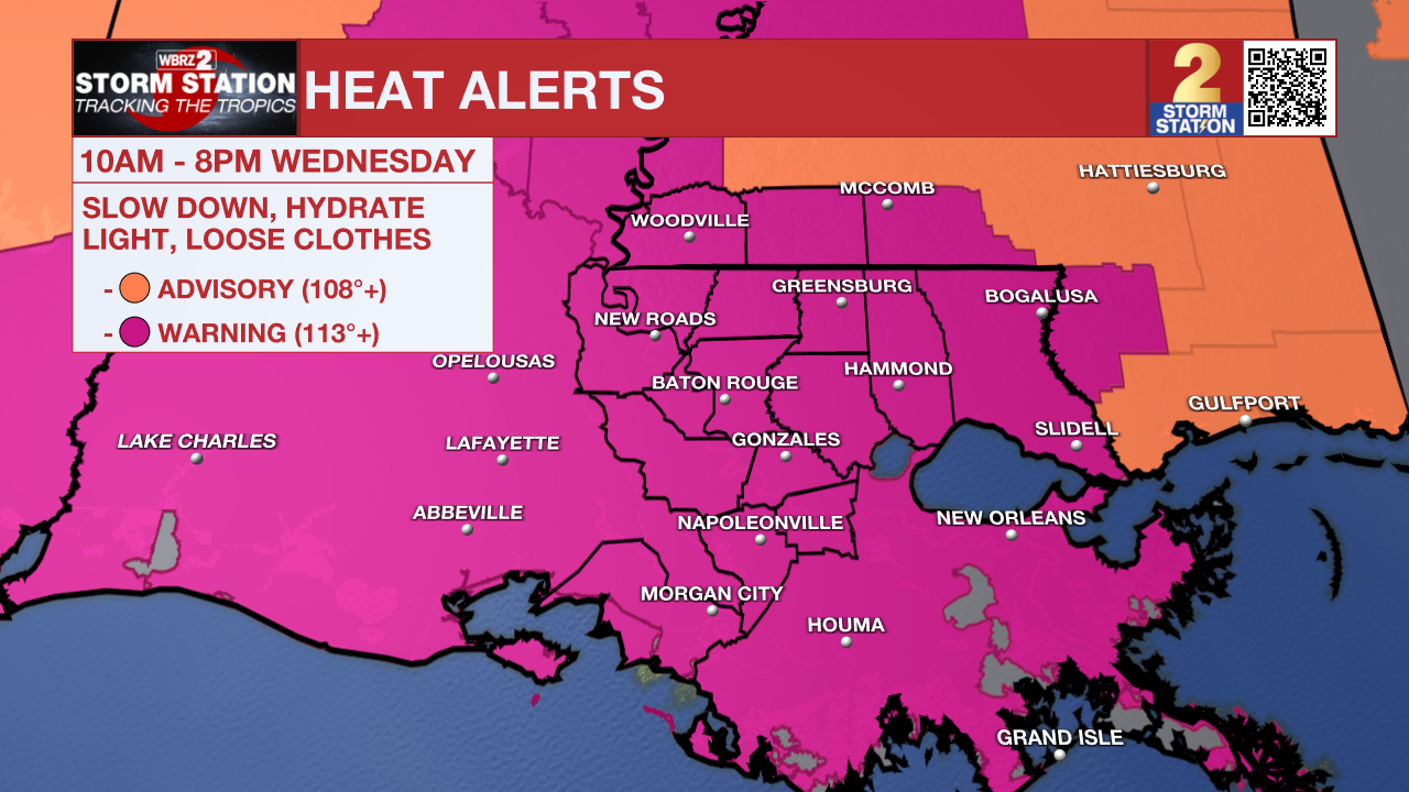
Heat is another part of the Storm Station forecast, which will remain despite Bertha being on approach. With highs now expected to reach 97° on Wednesday, Extreme Heat Warnings have been posted for the Capital Area as tropical moisture surges.
Today & Tonight: Isolated afternoon downpours have already developed and will continue through much of the afternoon, helping to take the edge off the heat. Check The Tropics section below for a full breakdown of the system spinning in the Gulf. Activity will trend down overnight, but spotty showers will remain possible. Lows will reach into the upper 70s.

The Tropics: Tropical Storm Bertha continues to slowly drift westward through the northeast Gulf. While the storm has strengthened in the last 24 hours, the storm will likely weaken as it approaches the Louisiana coast. Outer rainbands are rolling in as early as Tuesday afternoon and will stick around on an off-and-on again basis through Thursday. There will be a fair amount of dry time as the storm passes.

Current guidance shows the storm tracking south of Baton Rouge, sliding along the coastline or staying just offshore. That's good news for inland communities, where the Storm Station team expects fairly minimal impacts. Moderate wind shear is playing a big role here as it's capping the storm's intensity and making it lopsided, pushing most of the heavy rain and wind on the southern side of the system. Because of this, coastal areas are most at risk for minor surge, localized flooding, gusty winds, and heavy downpours, so keep an eye out for tropical alerts. Even with a lower-impact setup, you never turn your back on a tropical system. Be sure to check in daily with the Storm Station.
Trending News

Up Next: Periodic tropical downpours will continue through Thursday, especially south of I-10. Outside of these showers, intense heat and humidity will dominate. An Extreme Heat Warning will be in effect for Wednesday, as the peak heat index could approach 115°. This is a dangerous level of heat, so try to limit time outside during the afternoon and drink plenty of water. As the tropical system pulls away late in the week and into the weekend, the summer heat will continue to bake the Capital Area.
Get the latest 7-day forecast and real-time weather updates HERE.
Watch live news HERE.
— The Storm Station Meteorologists
The Storm Station is here for you, on every platform. Your weather updates can be found on News 2, wbrz.com, and the WBRZ WX App on your Apple or Android device. Follow WBRZ Weather on Facebook and X for even more weather updates while you are on the go.
More News

