

Latest Weather Blog
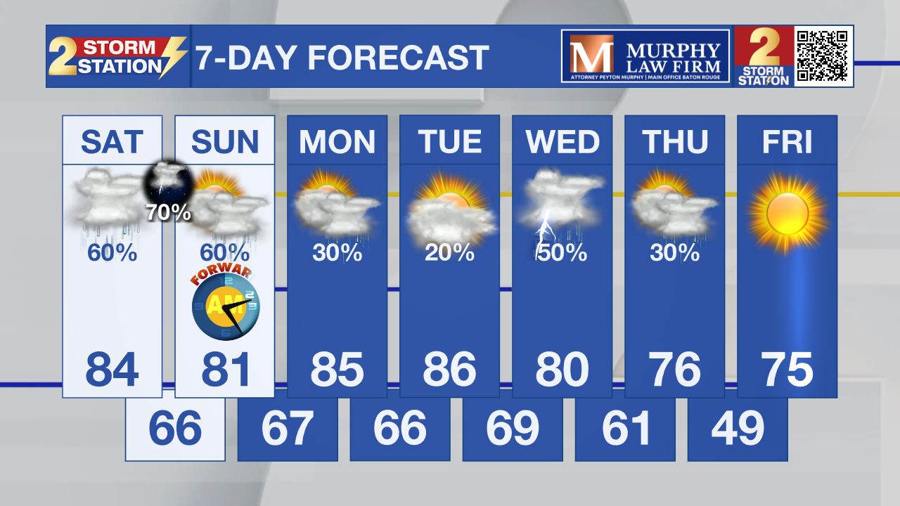
Saturday AM forecast: Afternoon storms likely, heavy rain possible overnight.
A few storms could become strong during the afternoon before heavier rain arrives late Saturday night into Sunday. Northern areas are in a Level 2 Slight Risk of severe weather, while the southern sections are at a Level 1 Marginal risk.

Today and tonight: Saturday will feel more like early summer across the Capital Region with highs climbing into the lower and middle 80s, roughly 10 to 15 degrees above normal. Scattered showers and thunderstorms may develop during the afternoon, especially north of the I-10/12 corridor, and a few storms could briefly become strong with gusty winds, small hail, and heavy downpours.

Use the slider to advance through the next 24 hours of Futurecast
Trending News
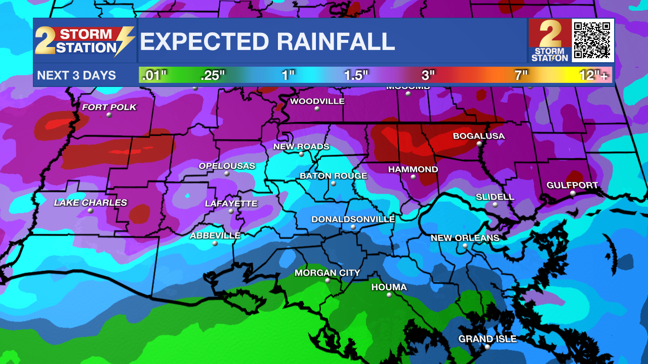
We’ll be watching a line of storms over northern and central Louisiana after sunset, which will move in Saturday night as a frontal boundary approaches Louisiana. Any severe weather will be limited to the northern areas of the Capital Region down to the interstates. Damaging wind will be the main threat. The system will be working with a tremendous amount of moisture, heavy downpours are possible, and brief street flooding could cause travel issues. Widespread flooding isn’t expected due to the recent dry conditions.
Timeline for pop-up afternoon storms will be 2-5 pm, and the main line of storms will push through overnight into early Sunday. Make sure you have ways to be alerted if any severe weather comes your way.
Up Next: Sunday is expected to bring a higher coverage of showers and thunderstorms as the frontal boundary gets closer to the region. Periods of heavier rain are possible during the morning, then weaken. If any sun returns during the afternoon and daytime heating gets going, scattered storms could redevelop. Improving conditions early next week, though scattered rain chances may linger into Monday. Another, stronger front is expected by the mid week. This will likely drop our temperatures to near normal values for early to mid March!
What to look out for: A few Saturday afternoon storms could briefly become strong with gusty winds, small hail, and intense rainfall as instability builds during peak daytime heating. The bigger concern may develop late Saturday night into Sunday when a larger area of rain and thunderstorms moves through, bringing the potential for locally heavy rainfall that could lead to ponding on roads and minor flooding in urban and poor drainage areas.
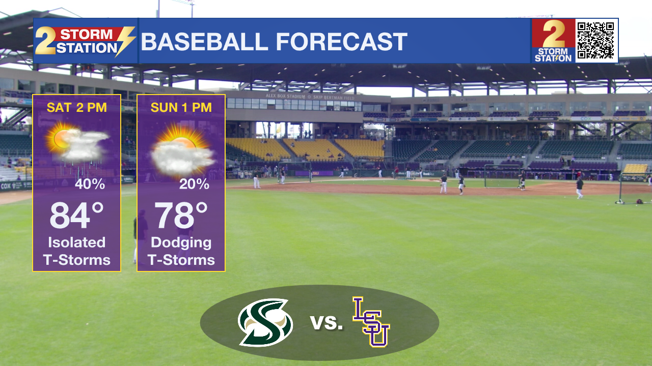
LSU Sports: LSU baseball hosts Sacramento State at Alex Box Stadium in Baton Rouge on Saturday at 2:00 PM CT. Warm and humid conditions are expected with highs in the lower to middle 80s during the afternoon. Scattered showers and thunderstorms are possible around game time, and while many storms should remain isolated, a brief delay or downpour cannot be ruled out for fans and players.
Get the latest 7-day forecast and real-time weather updates HERE.
Watch live news HERE.
– Dave
The Storm Station is here for you, on every platform. Your weather updates can be found on News 2, wbrz.com, and the WBRZ WX App on your Apple or Android device. Follow WBRZ Weather on Facebook and X for even more weather updates while you are on the go.
More News
