

Latest Weather Blog
Saturday PM Forecast: Fall almost here, the new season brings some changes
We are now almost one day away from the start of fall! As we enter the new season, we will see some changes next week.
Tonight & Tomorrow: A few clouds will hang around overnight, with temperatures easing to near 70 degrees. The forecast holds steady for Sunday, with partly sunny skies and highs in the low 90s. There will be some slight changes, in the form of a few more showers/storms. Available moisture will slightly increase as an upper-level disturbance passes through in the afternoon. This will cause isolated showers and storms. Given rain chances will not be overly high, there is no need to cancel outdoor plans.
Up Next: Rain coverage will dip back down to 20% Monday as we will be on the backside of the disturbance. Tuesday and Wednesday, available moisture will get much higher as another disturbance approaches. This will bump coverage up to the isolated and scattered category. Temperatures will stay for the most part unchanged. Thursday will likely be the transition day as a front approaches the area. There has been some uncertainty on whether this front passes or not, but the current forecast reflects a front passage. After the front, expect mainly dry conditions, and slightly cooler temperatures.
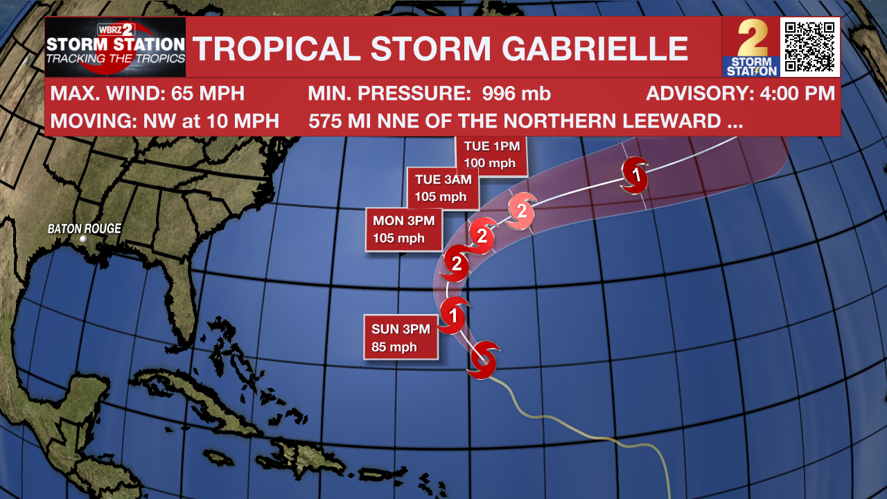
The Tropics: Hurricane Hunter aircraft found that Gabrielle briefly developed a tiny eye about 6 miles wide, with winds near 65 mph and a central pressure of 996 mb. The storm’s center was located a little farther east than expected, so the track has been adjusted slightly eastward and slowed down. Over the next couple of days, Gabrielle is expected to curve north, then northeast, staying well east of Bermuda, before turning more eastward later in the week. Conditions should allow the storm to strengthen steadily, possibly peaking near hurricane strength with winds around 105 mph, before weakening again as it moves into cooler waters and stronger upper-level winds.
Trending News
A tropical wave over the eastern Atlantic is producing disorganized shower and thunderstorm activity well southwest of the Cabo Verde Islands. Some slow development of this system is possible through the middle to latter part of next week while it moves west-northwestward across the eastern and central tropical Atlantic.
Get the latest 7-day forecast and real-time weather updates HERE.
Watch live news HERE.
– Balin
The Storm Station is here for you, on every platform. Your weather updates can be found on News 2, wbrz.com, and the WBRZ WX App on your Apple or Android device. Follow WBRZ Weather on Facebook and X for even more weather updates while you are on the go.
More News
