

Latest Weather Blog
Sunday AM forecast: Winter starts today, but it doesn't feel like it!
The winter solstice occurs today at 9:03am, officially beginning the astronomical winter season. This is the point where the sun is at its lowest angle, and we experience the least amount of daylight than any other day of the year. After Sunday, days will get a little longer each day until June. After a foggy start, Sunday brings a warm and muggy feel with areas of light rain later in the day. After today’s unsettled weather, a dry and unusually warm stretch settles in.
.png)
Today and tonight: Sunday starts off warm and humid with dense fog likely during the morning, especially across western areas. Visibility may be briefly reduced before fog lifts by mid to late morning. Skies stay mostly cloudy through the day as a weak boundary moves into the region. Scattered light showers develop during the afternoon and evening, with rain chances 50%. Rainfall will remain light, generally under a half inch, with no severe weather expected. Afternoon highs reach the low to mid 70s.

Use the slider to advance through the next 24 hours of Futurecast
Trending News
Tonight, a few light showers may linger before tapering off, and conditions remain mild and humid with lows in the lower to mid 60s. Patchy fog could redevelop late tonight.
Up Next: As we move into Monday and the rest of the upcoming week, high pressure becomes the dominant weather feature across the region. This will shut down rain chances for several days, setting up a long stretch of dry weather. Southerly winds will continue to pull warm, moist air into the area, keeping temperatures well above normal. Afternoon highs will stay in the low to mid 70s, with a few locations possibly approaching the upper 70s as we head closer to Christmas. Overnight lows remain mild, generally in the mid to upper 50s.
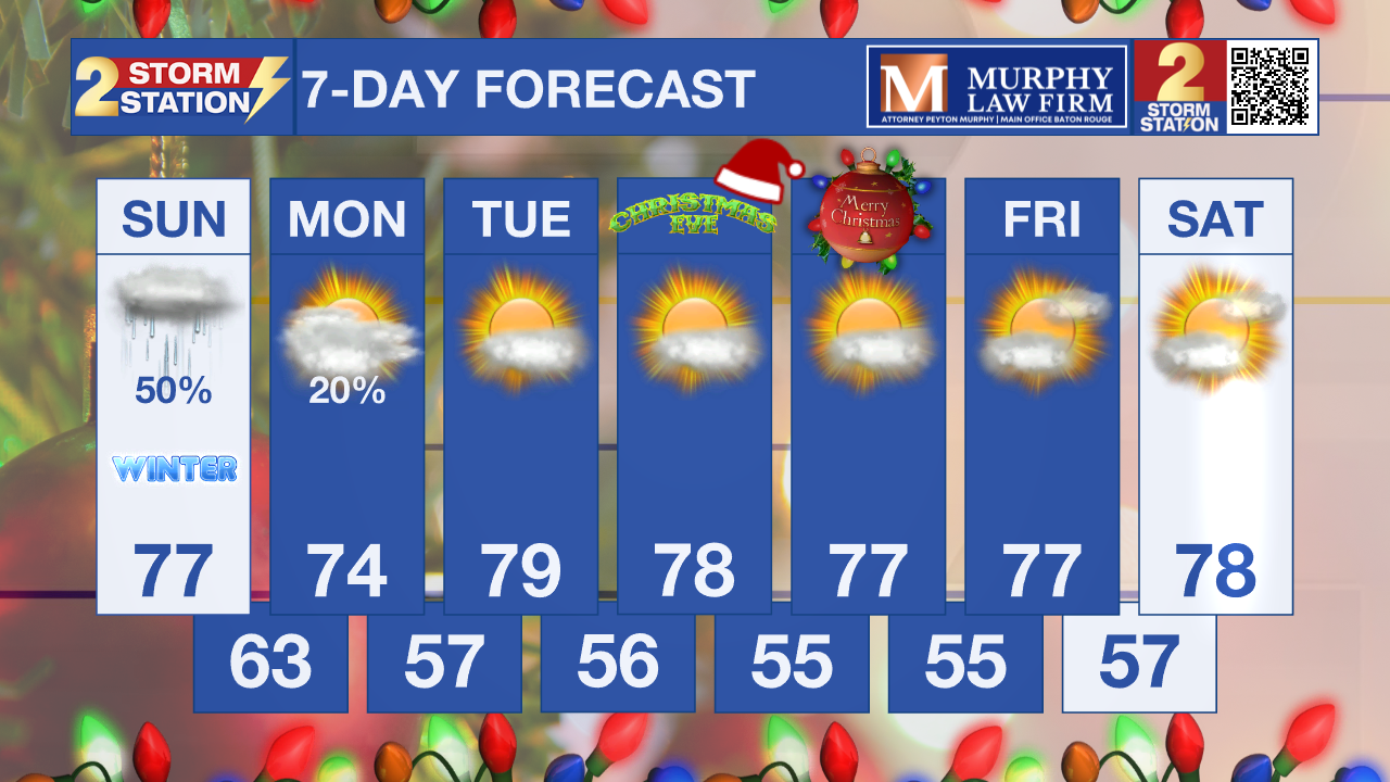
What to look out for: The main impacts today will be patchy dense fog during the morning hours and periods of light rain later in the day. While rainfall amounts will stay low and no severe weather is expected, damp roads and reduced visibility could cause minor travel slowdowns at times. Warm and humid conditions will also continue through tonight, allowing fog to redevelop late and early Monday morning in some areas.
Get the latest 7-day forecast and real-time weather updates HERE.
Watch live news HERE.
– Dave
The Storm Station is here for you, on every platform. Your weather updates can be found on News 2, wbrz.com, and the WBRZ WX App on your Apple or Android device. Follow WBRZ Weather on Facebook and X for even more weather updates while you are on the go.
More News
