

Latest Weather Blog
Sunday PM Forecast: Morning fog, warm afternoons, rain possible by late week
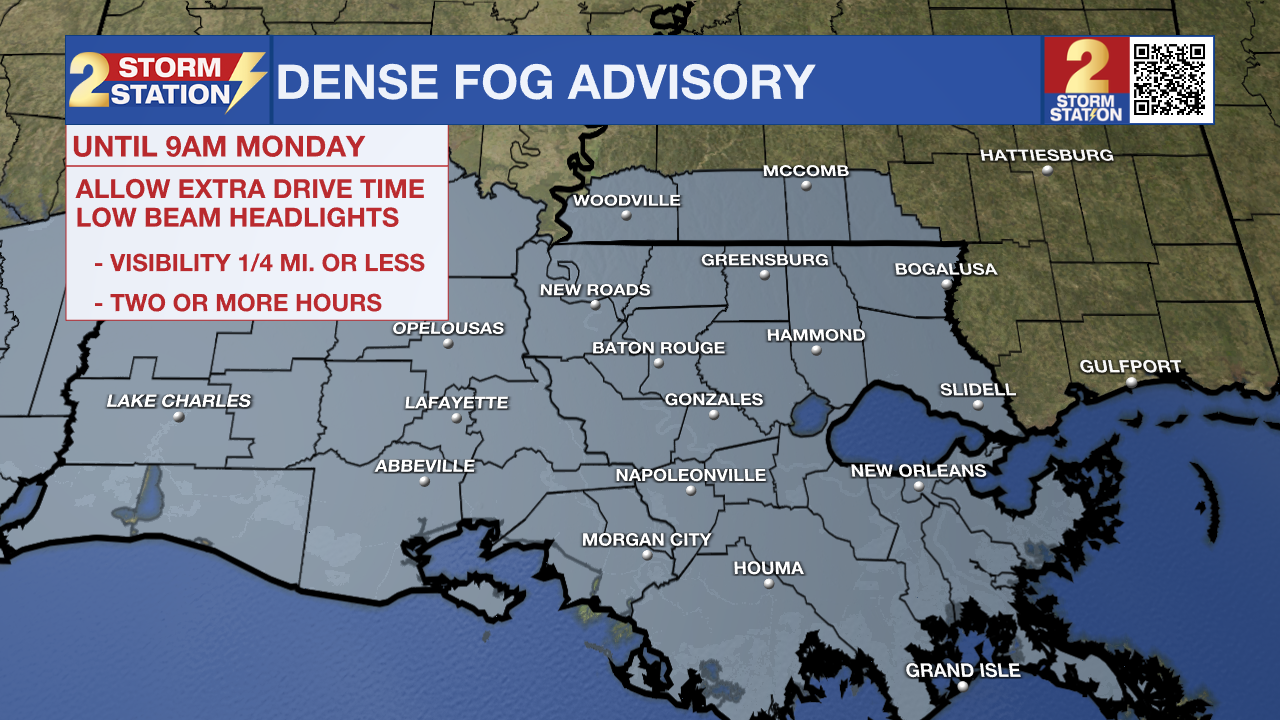
A Dense Fog Advisory has been issued for the entire Capital Region until 9 a.m. Monday. Early morning fog could make driving conditions hazardous for the morning commute. Pockets of dense fog with one-quarter-mile visibility or less will be possible, with localized areas near active or smoldering fires experiencing super fog with near-zero visibility. When driving through fog, remember to slow down and use low-beam headlights, which cut through fog more easily. If super fog is encountered, reduce speed significantly and keep headlights on even after the sun rises to keep tail lights visible.
Tonight & Tomorrow: Expect a mostly clear and mild night ahead with lows running ~10° above average in the upper 50s. Rapid cooling under calm, clear conditions will help result in areas of fog overnight. More areas might experience it this time due to a slight uptick in moisture near the surface. Keep that in mind for the morning commute. While it isn’t expected to be widespread, a few localized pockets of super fog with near-zero visibility will be possible. Super fog is the result of smoke mixing with fog, and Futurecast hints at that potential in St. James and St. John the Baptist Parishes, in addition to areas near I-55 and I-12 in Livingston and Tangipahoa Parishes. Be extra careful if traveling east on I-10 or I-12. Meteorologist Dave Baker will be keeping an eye on conditions from 5-9 a.m. on 2une-In.
Any fog that develops will lift by mid-morning, giving way to a mix of clouds and sun. It will be warm during the afternoon with highs in the low 80s, along with a touch of humidity at times.
Up Next: The forecast will be on repeat through midweek, though temperatures will climb a bit. Mornings will be mild with patchy fog, and followed by warm, partly sunny afternoons. With highs near 84° on Tuesday and Wednesday, temperatures will be within a few degrees of record territory. Meanwhile, lows will return to the 60s, a symptom of rising humidity. Be ready to encounter a muggy feel by midweek. But even with more moisture around, rain will remain scarce, as an appropriate “triggering” mechanism will be lacking. That could change by the end of the week.
Next Chance of Rain: Late Thursday and into Friday, a frontal system will come into view. This should be enough to generate on-and-off showers and thunderstorms, though the exact timing is still unclear. New data also suggest the front could even stall to the northwest, possibly prolonging rain chances into the weekend. It’s still nearly a week out, so many of these forecast questions will become clearer with time. Check back with the Storm Station later in the week as confidence improves. For now, just know that this could be the Capital Area’s next shot at meaningful rain.
The Tropics: For the Gulf, Caribbean, and Atlantic, all is quiet. No new tropical development is expected over the next seven days.
Trending News
Get the latest 7-day forecast and real-time weather updates HERE.
Watch live news HERE.
— Meteorologist Malcolm Byron
The Storm Station is here for you, on every platform. Your weather updates can be found on News 2, wbrz.com, and the WBRZ WX App on your Apple or Android device. Follow WBRZ Weather on Facebook and X for even more weather updates while you are on the go.
More News
