

Latest Weather Blog
Sunday PM Forecast: Mostly sunny skies and warm temps ahead for the upcoming week
A stretch of mostly sunny, warm spring weather is expected this week, with only a slight chance of a sprinkle on Tuesday. Temperatures will range from cool mornings in the 50s to warm afternoons in the 80s, making for a pleasant and mostly dry forecast.
Tonight & Tomorrow: We’re looking at a quiet and pleasant end to the weekend and start to the new week. Skies will stay clear tonight, with temperatures dipping into the mid 50s to low 60s. On Monday, expect a beautiful spring day. Sunshine will dominate again, although a few fair-weather cumulus will be possible in the afternoon and evening. Highs will be warm, in the low to mid 80s. All in all, it’ll be a great day to spend some time outdoors!
Up Next: Tuesday brings a slight change as a weak front moves through, but it’s nothing dramatic. You might notice a shift in wind and slightly cooler temperatures, especially by Wednesday. There’s only a slight chance (10%) of a stray sprinkle Tuesday, mainly in northern areas—but most folks won’t see a drop.
Wednesday will start off nice and crisp, in the low 50s. During the day, sunshine returns in full force with highs in the upper 70s. As we move toward the end of the week, temperatures gradually warm back into the mid to upper 80s. Skies will be mostly to partly sunny, and rain chances remain slim (just a 10% coverage Saturday and Sunday).
It’s shaping up to be another fantastic week ahead—mild nights, warm days, and plenty of sunshine. Spring weather at its best!
Trending News
River Flooding: The National Weather Service has issued a RIVER FLOOD WARNING for the Mississippi River at Red River Landing until further notice. A RIVER FLOOD WARNING will go into effect late Monday for the Mississippi River at Baton Rouge.
• At Red River Landing, flood stage is at 48 feet. Minor flooding is forecast by Friday evening. Moderate flooding is expected with a crest near 57 feet on April 23. Around these levels, Angola farmland on the left bank begins taking on water. Caution is urged when walking near riverbanks.
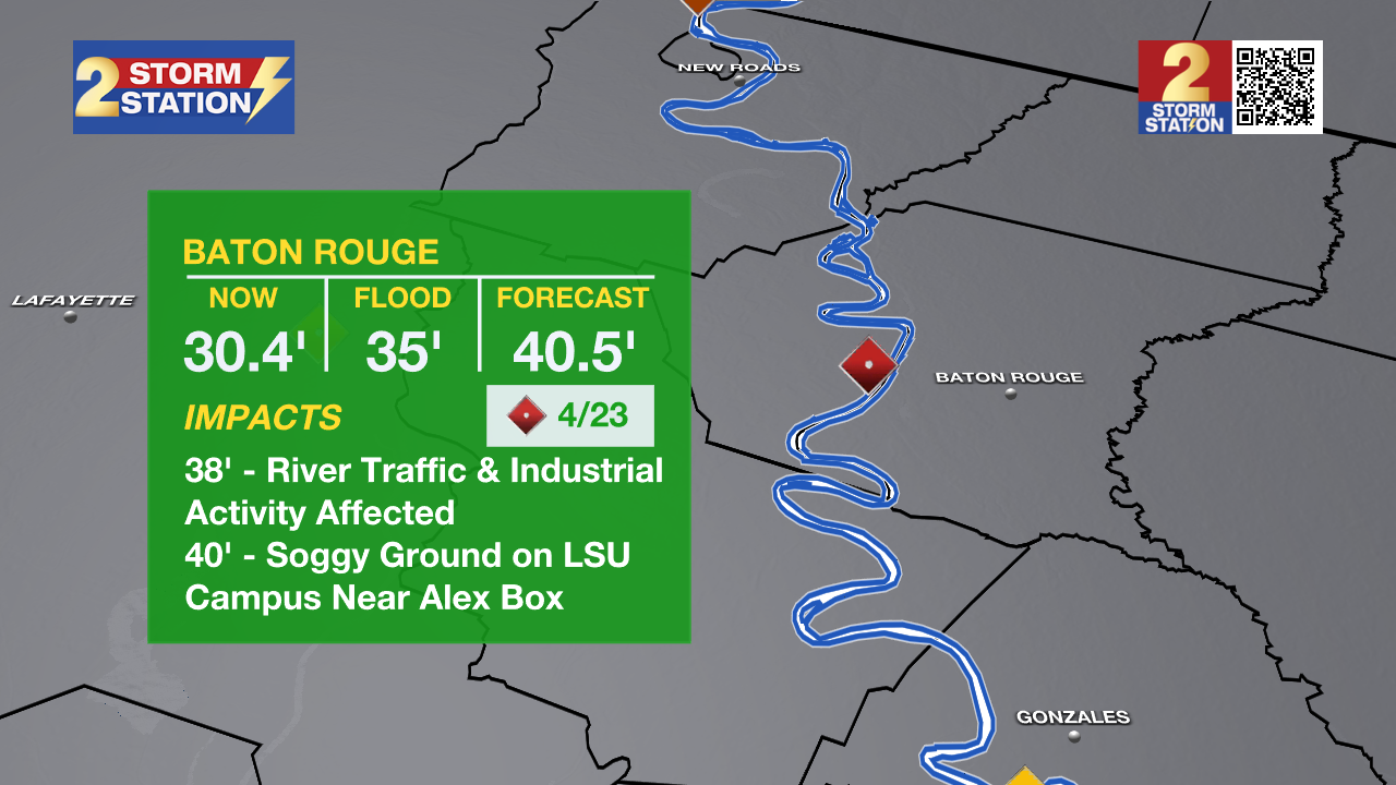
• At Baton Rouge, flood stage is 35 feet. Minor flooding is forecast to begin early Tuesday, cresting just above major flood stage on April 23 with a height of 40.5 feet. Levels will fall below flood stage around May 2. Around these levels, the grounds of the older part of Louisiana State University's campus become soggy. This includes the area around the Veterinary Medicine building, the Veterinary Medicine Annex, and Alex Box Stadium. Levees protect the city of Baton Rouge and the main LSU campus at this level. Caution is urged when walking near riverbanks.
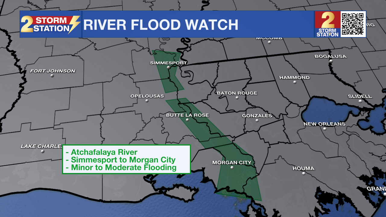
The National Weather Service has issued a RIVER FLOOD WATCH for the Atchafalaya River at Simmesport, Butte La Rose, and Morgan City until further notice.
• At Simmesport, flood stage of 40 feet may be reached by April 24. There will be flooding of areas inside the levees of the Atchafalaya Floodway and considerable flooding in the backwater storage area in Avoyelles Parish.
• At Butte La Rose, flood stage of 20 feet may be reached by April 24. Minor flooding of the nearby areas could occur.
• At Morgan City, flood stage of 6 feet may be reached by April 19. Moderate flooding at 7 feet is forecast by April 23. At 7 feet, buildings at the foot of Ann Street on the river side of the flood wall will flood as water overtops the Rio Oil Company dock. Buildings on the river side of the Berwick floodwall will flood. River traffic restrictions will be strictly enforced. In addition, backwater flooding could potentially impact portions of areas around Lake Palourde and Stephensville.
Get the latest 7-day forecast and real-time weather updates HERE.
Watch live news HERE.
-- Balin
The Storm Station is here for you, on every platform. Your weather updates can be found on News 2, wbrz.com, and the WBRZ WX App on your Apple or Android device. Follow WBRZ Weather on Facebook and X for even more weather updates while you are on the go.
More News
