

Latest Weather Blog
Thursday AM Forecast: Cold front tonight brings isolated storms, Cooler and drier air arrives behind it
The highly anticipated cold front that will end the streak of very muggy and warm days arrives late tonight. A cooler and drier air mass will move in just in time for the Mother's Day weekend!
Today & Tonight: Thursday begins with more warm weather, early morning low's around the Capital Region will only fall into the upper-70s, feeling even warmer thanks to the humidity. Today will be the last extremely warm and muggy day of the week despite additional clouds around. Temperatures this afternoon will warm back into the low-90s with heat index values topping out around 100°. Winds will remain out of the south all day until a cold front passes through overnight.
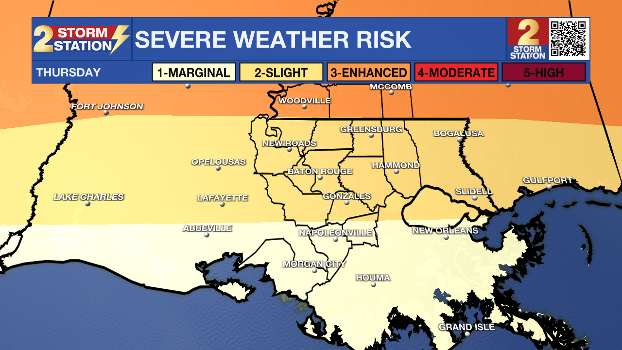
As the cold front arrives very late Thursday into the early hours of Friday morning, a few isolated storms along the front could become strong to even severe. The highest threat comes the further north you are in the Storm Station coverage area. Southwest Mississippi counties have been upgraded to a 3/5 risk for severe storm development; the Capital City and surrounding parishes remain in a 2/5, slight risk, for strong to severe storms. Strong, damaging winds are of highest concern with this system. We are expecting 30% coverage with this event, so some may not even see rain overnight.
Up Next: The cold front and any associated storms are expected to clear the state by sunrise Friday. Behind the front, winds take a northerly turn and will help usher in the cooler and drier air. With clearing skies, Friday will see temperatures well into the 80s but by Saturday morning, cool temperatures replace the muggy morning feel we've had all week. Both Saturday and Sunday will see morning lows in the 60s and afternoon highs in the low 80s. Saturday will be a very, very nice day will lost of sun and low humidity levels. Sunday, aka Mother's Day, will see a bit more cloud cover as the former cold front will make a return up from the gulf, this time as a warm front. As the new front moves north, isolated showers may develop during the day on Sunday, but a greater coverage of rain is expected to start off the workweek.
Get the latest 7-day forecast and real time weather updates HERE.
Trending News
Watch live news HERE.
– Emma Kate Cowan
The Storm Station is here for you, on every platform. Your weather updates can be found on News 2, wbrz.com, and the WBRZ WX App on your Apple or Android device. Follow WBRZ Weather on Facebook and Twitter for even more weather updates while you are on the go.
More News
