

Latest Weather Blog
Thursday AM Forecast: Great weather through end of week, wet stretch ahead
Lots of sunshine and cold mornings give way to a much wetter pattern later this weekend. A series of fast-moving storm systems will bring rounds of rain and possibly a few thunderstorms Sunday through Tuesday.
Thursday & Friday: Cold air continues to spill into the region, keeping us well below normal for late November. Highs will only reach the upper 50s to lower 60s, and despite sunshine, it will feel crisp throughout the day thanks to dry northwest winds. Clear skies and calm winds will allow temperatures to tumble again tonight. Most spots fall into the 30s to lower 40s, with the coldest readings north of I-10/12. Patchy frost is possible, so cover or bring sensitive plants inside. Friday will be rinse and repeat, although we will have filtered sunshine at times.
Football Forecasts: Friday night lights across the Capital Area look fantastic, with clear skies, light breezes, and temperatures sliding into the 40s by halftime—definitely a night for warm layers. Southeastern Louisiana’s playoff matchup should kick off dry, though clouds will build as the day goes on and a spotty shower can’t be ruled out late. Fans heading to the indoor Bayou Classic in New Orleans on Saturday can expect mild, dry weather going in, but increasing cloud cover and a slight chance of a shower on the drive home. Meanwhile, LSU’s trip to Oklahoma is shaping up to be damp and chilly, with some morning rain and temperatures dropping from the 50s into the 40s during the afternoon.
Up Next: By Saturday, winds shift from the east and eventually southeast, allowing temperatures to warm back into the upper 60s to low 70s. Moisture increases quickly, but only isolated showers are expected.
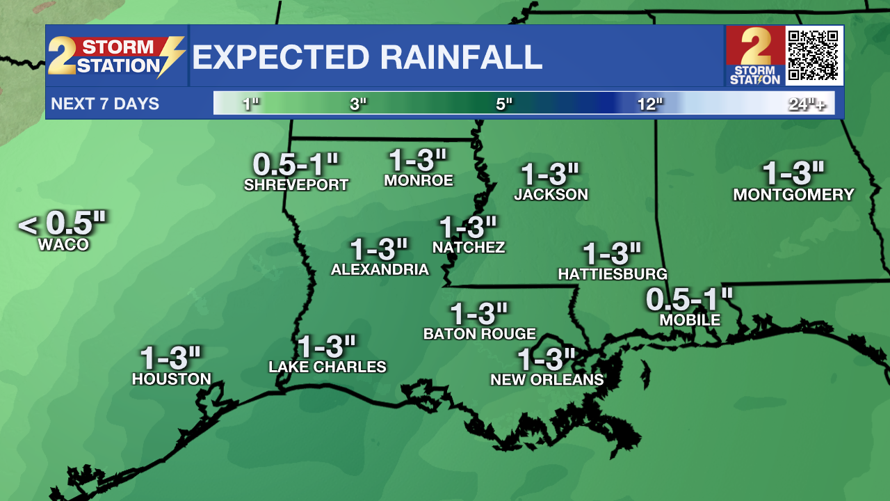
Late Saturday night into Sunday, the first in a series of disturbances brings rain and a few thunderstorms. Rain could be heavy at times, especially west of I-55, with 1–2 inches common and pockets up to 3 inches by Sunday evening—welcome news for dry soils. Temperatures stay near normal but may peak earlier in the day Sunday as a weak front sags south.
Trending News
Forecast confidence drops slightly early next week due to model differences on where the front stalls, but the overall signal is clear: Monday and Tuesday look wet again. A developing Gulf low will tap into extremely moist air, sending another round of rain across the region. Temperatures trend cooler, with lows ranging from the upper 30s to low 50s and highs mainly in the 50s both days.
A stronger cold front sweeps through Tuesday afternoon, clearing skies and ushering in brighter, cooler, and much drier weather by Wednesday.

The Tropics: For the Gulf, Caribbean, and Atlantic, all is quiet. No new tropical development is expected over the next seven days.
Get the latest 7-day forecast and real-time weather updates HERE.
Watch live news HERE.
– Balin
The Storm Station is here for you, on every platform. Your weather updates can be found on News 2, wbrz.com, and the WBRZ WX App on your Apple or Android device. Follow WBRZ Weather on Facebook and X for even more weather updates while you are on the go.
More News
