

Latest Weather Blog
Thursday AM Forecast: Turning stormy on this weekend full of events
Although the weather will stay largely quiet through the end of the workweek, that will change as we head into the weekend. Our next weather system will bring widespread storms late Saturday into Sunday.
Rest of Workweek: Fog shouldn’t be much of a concern this morning, though a few isolated patches can’t be ruled out. A weak front sliding through will shave temperatures down a bit today, with highs settling into the mid-70s beneath mostly cloudy skies. As the boundary lifts back north later this afternoon, a few spotty showers may develop. Overnight, look for lows near 57° and the potential for some patchy fog toward daybreak. Warmer air surges back in on Friday, sending highs into the 80s. While a couple of showers are possible again, they appear minimal. Attention then turns to a much stronger system set to move in over the weekend.

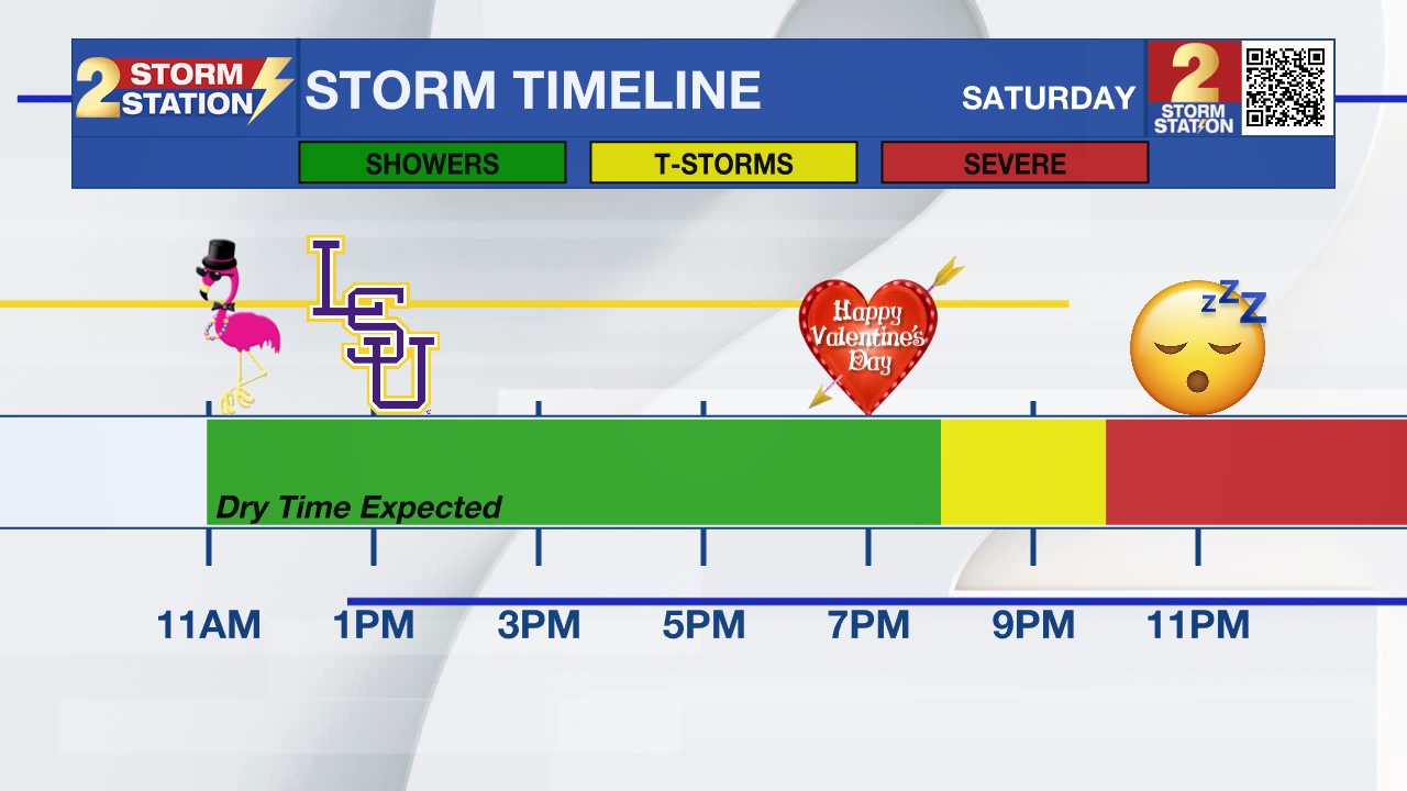
Mardi Gras Weekend: As a cold front approaches the area on Saturday, southerly winds will begin to increase. This will allow warm and moist air to pump into the region, and even create some showers. Most of the day will feature scattered light to moderate showers, especially in the afternoon and evening. A washout is not expected, and you will even find a lot of dry time during the daylight hours. So if you plan on going to the Spanish Town Parade, LSU baseball game, or just a date in the evening, there is no need to cancel your plans. Highs will reach near 80 degrees under mostly cloudy skies.
Trending News
Activity gets much more widespread as we enter the overnight hours, especially between 12am-6am. As a strong disturbance swings through, and a cold front enters, a line of showers and storms will pass. Although the severe risk is low at this time, a stronger storm is not out of the question. Considering this will be rolling through when most are asleep, make sure you have a way to receive alerts! Rain totals should be manageable, with most picking up near an inch.
Sunday & Beyond: Clouds will hang around through Sunday, though we should catch a few breaks of sunshine here and there. A stray shower can’t be ruled out, so it wouldn’t hurt to have an umbrella nearby. Afternoon temperatures will top out close to 70 degrees.
Lundi Gras begins on a mild note with morning readings around 50 degrees, followed by a warmup into the low to mid-70s by the afternoon. Mardi Gras looks similar, with dry conditions and highs in the mid-70s. Let the good times roll!
Get the latest 7-day forecast and real-time weather updates HERE.
Watch live news HERE.
— Balin
The Storm Station is here for you, on every platform. Your weather updates can be found on News 2, wbrz.com, and the WBRZ WX App on your Apple or Android device. Follow WBRZ Weather on Facebook and X for even more weather updates while you are on the go.
More News
