

Latest Weather Blog
Tuesday PM Forecast: Another wave of storms targeting Capital Area, FLOOD WATCH issued
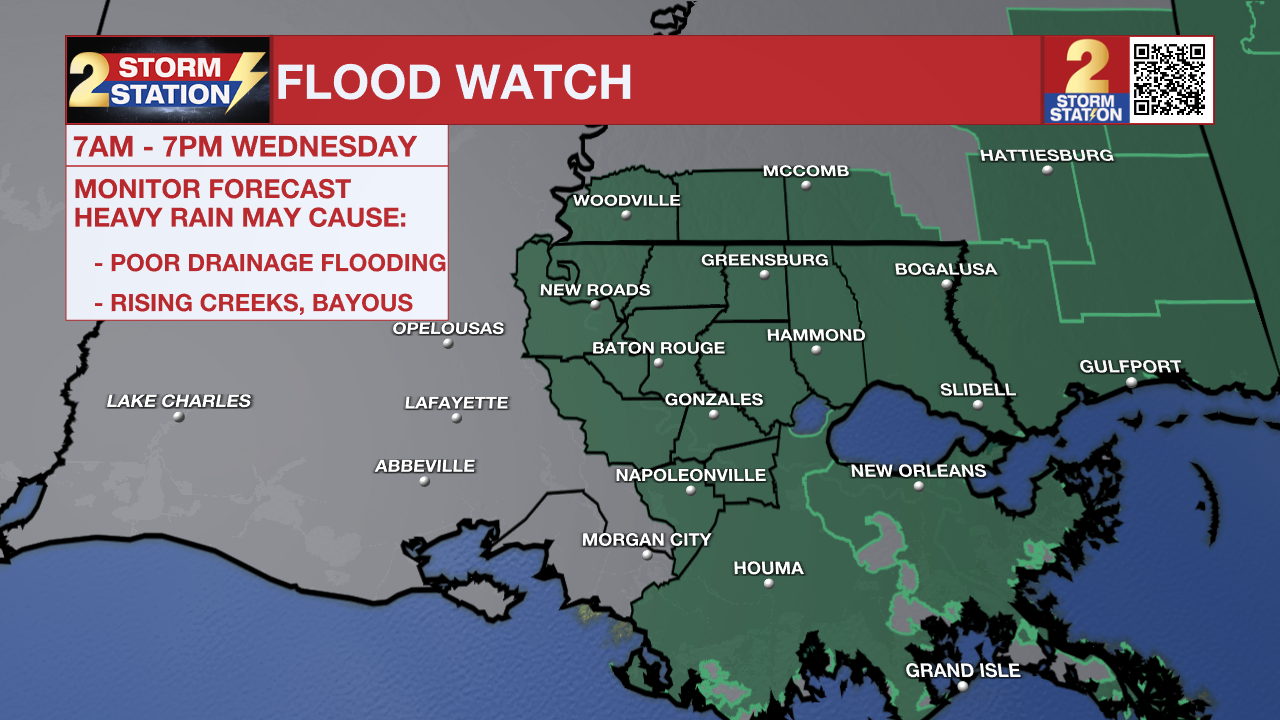
The National Weather Service has issued a FLOOD WATCH for East Baton Rouge, West Baton Rouge, Ascension, Assumption, Iberville, East Feliciana, Livingston, Pointe Coupee, St. Helena, St. James, Tangipahoa, and West Feliciana Parishes, as well as Amite and Wilkinson Counties, from 7 a.m. to 7 p.m. Wednesday.
A FLOOD WATCH means conditions may develop that lead to flash flooding. Flash flooding is a very dangerous situation. Be on the lookout for threatening weather conditions and listen for later statements and possible warnings. For more on flooding safety, CLICK HERE.
Tonight & Tomorrow: Despite some evening clearing, more clouds will fill back in by daybreak. Wednesday will begin muggy and mild with wake-up temperatures in the low 70s. Wednesday looks to feature a greater number of showers and thunderstorms. With a line of storms advancing toward the Capital Area overnight, they could arrive as early as mid-morning. Storm chances will persist as the day wears on, with roughly 80% of the Capital Region experiencing a downpour at some point. Highs have the potential to reach the mid-80s, but that will be closely tied to the timing of rain.
Since the atmosphere will be packed with moisture, Wednesday's storms will be highly efficient rainmakers. The heaviest downpours will dump 1-3" of rain per hour, which could overwhelm local drainage systems. Be extra cautious while driving through heavy rain and look out for ponding on the roads. Never attempt to drive through flooded roads or pass barricades, as it only takes a small amount of standing water to stall a vehicle.
Up Next: While the latest Flood Watch expires at 7 p.m. Wednesday, another Flood Watch may be needed on Thursday. This will all come down to how much moisture is left behind after Wednesday's storms. New data as of Tuesday evening show things trending a little drier on Thursday. For now, the Storm Station maintains scattered to numerous thunderstorms in the forecast.

Trending News
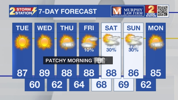
Rain remains possible on Friday, although new data suggest slightly drier air will try to creep in, which would help shrink the storm coverage. That drying trend will continue into Saturday with only isolated pop-up storms expected in the heat of the day. In turn, temperatures will climb higher toward the 90° mark. Looking ahead to Sunday and Monday, there are signs that a weak “cold” front will approach the area, allowing for a slight uptick in the number of showers and storms again. If that front manages to clear the area early next week, it would drag away the sticky humidity and push the rain toward the coast. That scenario isn't a guarantee just yet, so be sure to check back with the Storm Station as the forecast becomes further refined.
Get the latest 7-day forecast and real-time weather updates HERE.
Watch live news HERE.
— Meteorologist Malcolm Byron
The Storm Station is here for you, on every platform. Your weather updates can be found on News 2, wbrz.com, and the WBRZ WX App on your Apple or Android device. Follow WBRZ Weather on Facebook and X for even more weather updates while you are on the go.
More News

