

Latest Weather Blog
Tuesday PM Forecast: fewer showers ahead, heat continues to end summer
Any rainfall on Tuesday will not be enough to make a dent in the ongoing dry spell. For the rest of the week, rain chances go lower while afternoon temperatures stay high.
Rest of the Week: Showers will diminish after nightfall, but a weak impulse in the atmosphere will leave a small rain chance in place overnight. Lows will bottom out in the low 70s under partly cloudy skies. Wednesday through Friday, a fair-weather producing, high-pressure system will tighten its grip, cutting daily rain coverage down to just 10%. Expect plenty of sunshine. Highs will top out in the low 90s. Humidity levels will be seasonably high, so it will feel sticky, but not summer bad.
Friday Night Blitz: Skies will be mostly clear with just a few passing clouds and no significant rain concerns. Temperatures will start in the upper 80s for kickoff, but quickly cool into the upper 70s by the second half of the games. We can call this warm but comfortable with a light breeze.
LSU Football: If you are heading to LSU on Saturday for tailgating or the game, expect a mostly sunny and hot day with highs in the low 90s. Much like last weekend, sunscreen, hydration, and breaks in the shade will be key for tailgaters. Rain coverage of only about 10% is expected, so it’s unlikely that showers will interfere. It will stay sticky through kickoff into the evening with temperatures dropping out of the 90s into the low 80s.
Up Next: For the weekend as a whole, the pattern will not change much. Saturday and Sunday both bring a non-zero chance for showers, but most outdoor plans and weekend events should stay dry. Highs will hover in the low 90s, with mornings in the upper 60s. By early next week, we may see a slight pattern change, but barely noticeable with rain coverage trying to move toward 20-30%.
Trending News
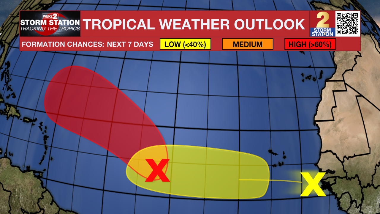
The Tropics: A broad area of low pressure located about midway between the Windward Islands and the Cabo Verde Islands is showing better organization. Environmental conditions are favorable, and a tropical depression or even a tropical storm is likely to form within the next day or two as the system tracks west-northwest to northwest at 10–15 mph.
Another tropical wave just off the coast of Africa is producing disorganized showers and storms. Development here is expected to be slow, with only a 20% chance of formation within 7 days as it pushes westward across the open Atlantic.
At this time, neither system poses an immediate threat to the Gulf Coast. However, some of the northern Caribbean Islands, Bermuda, and possibly the Eastern U.S. should monitor.
Get the latest 7-day forecast and real-time weather updates HERE.
Watch live news HERE.
– Josh
The Storm Station is here for you, on every platform. Your weather updates can be found on News 2, wbrz.com, and the WBRZ WX App on your Apple or Android device. Follow WBRZ Weather on Facebook and X for even more weather updates while you are on the go.
More News
