

Latest Weather Blog
Tuesday PM Forecast: passing showers and thunderstorms remain possible each day
Daily afternoon thunderstorms will move through the area this week as a moist and unsettled weather pattern takes hold. A cold front could bring cooler temperatures and rain to the region by Easter Sunday.
Wednesday: scattered storms during the afternoon
Thursday: highest “coverage” day in terms of rain
Easter: cooler and damp

Trending News
Tonight & Tomorrow: Shower activity will taper off overnight with temperatures settling in the mid-60s. On Wednesday, we will kick off the month of April with more of the same pattern. Expect highs in the mid 80s with humidity you will feel the moment you step out the door. While morning should stay relatively dry for the commute, scattered thunderstorms will develop during the heat of the afternoon. The 3:00 PM to 6:00 PM window looks most active, and this is also when lightning is most likely. While any thunderstorms will not be severe, any storm that sits over one neighborhood could drop a quick inch of rain and cause some temporary ponding on the roads.
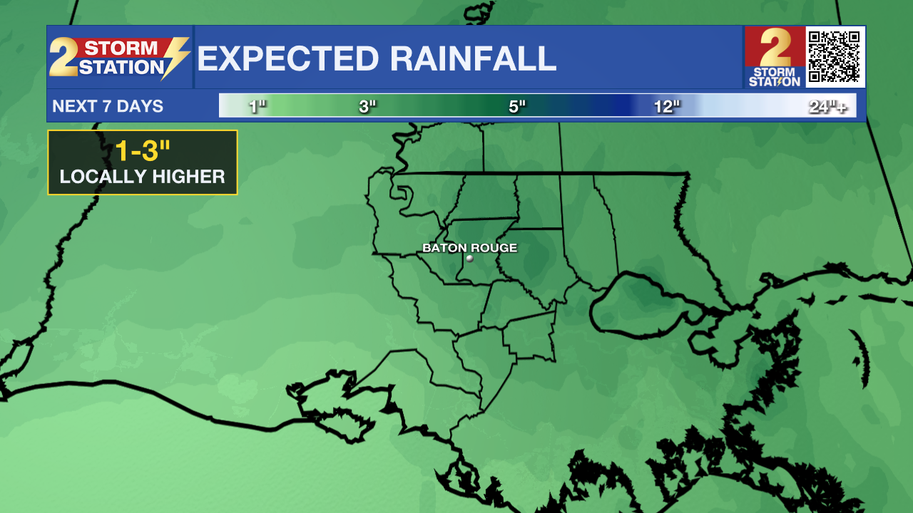
Up Next: The showery and muggy pattern will stick around through the end of the week. Scattered showers and thunderstorms will be a fixture of each afternoon, though not every neighborhood will see rain every day. Most neighborhoods should pick up between 1 inch and 3 inches of total rainfall by early next week. Widespread flash flooding is unlikely, but some storms could produce brief ponding on roads in isolated areas. Fortunately, severe weather is not expected.
Temperatures will stay mild with highs in the mid-80s through the weekend, especially Saturday. Lows will range from the mid-60s to the low 70s.
Thursday stands out as the busiest day of the week. An upper-level disturbance will move through and trigger a higher number of showers and thunderstorms.
A cold front will move into the area by Easter Sunday. The most likely scenario is a cooler, gray, and damp day across the region. If holiday plans involve a crawfish boil, backyard cookout, or egg hunt, have an indoor backup plan ready in case showers and thunderstorms are overhead. Highs Sunday and Monday could drop to the upper 60s behind the front.
Get the latest 7-day forecast and real-time weather updates HERE.
Watch live news HERE.
– Josh
The Storm Station is here for you, on every platform. Your weather updates can be found on News 2, wbrz.com, and the WBRZ WX App on your Apple or Android device. Follow WBRZ Weather on Facebook and X for even more weather updates while you are on the go.
More News
