

Latest Weather Blog
Wednesday AM Forecast: Another sticky day with storms, a weak front closing in
Another warm and sticky day with scattered showers and thunderstorms is ahead. A weak front arrives to spice things up heading into Thursday, which could result in a brief humidity break for some. Nevertheless, it won’t take long for the classic summer pattern to come roaring back.
Today & Tonight: It’s another one of those days to keep the rain gear handy. While much of the day looks dry, a healthy scattering of showers and thunderstorms will develop with daytime warming. With a 70% rain coverage across the Capital Area, the majority will experience rain at least once before sunset. Just like recent days, these storms will feature frequent lightning, torrential rain, and the occasional damaging wind gust. Thanks to cloud cover, Wednesday looks relatively cooler overall, with highs stopping a few degrees short of 90°. However, the unrelenting humidity will nudge the heat index, or feels-like temperatures, into the mid-90s at peak warming.

Use the slider to advance through the next 24 hours of Futurecast
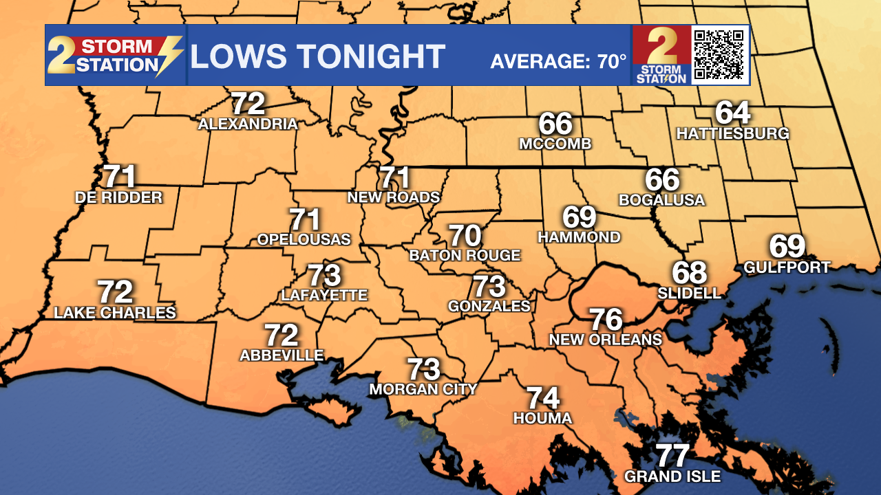
A handful of storms may linger after dark before eventually fizzling late. The overnight forecast brings more flavor as a weak front slides into the region. As dry air moves in, areas northeast of Baton Rouge could sneak into the mid-to-upper 60s for overnight lows. Meanwhile, locations holding onto a bit more moisture will remain firm in the 70s.
Up Next: With a front stalling over the area on Thursday, the forecast will split into two. Areas along and south of I-10 won't see much relief from the humidity, and these locations will face the highest risk of an isolated storm. On the other hand, areas to the north will enjoy a subtle drop in humidity and relatively drier conditions. There will be a brisk east wind at 10-20 mph as well. The front will lose its grip on the Capital Area heading into the weekend, allowing tropical moisture to surge back inland. This will set the stage for a classic summer weekend featuring a combination of high heat, sticky humidity, and scattered afternoon storms. While there will be some dry time over the weekend, do have a lightning shelter in mind.

Trending News

The Tropics: No tropical development is expected across the Atlantic Basin over the next seven days.
Get the latest 7-day forecast and real-time weather updates HERE.
Watch live news HERE.
— Meteorologist Malcolm Byron
The Storm Station is here for you, on every platform. Your weather updates can be found on News 2, wbrz.com, and the WBRZ WX App on your Apple or Android device. Follow WBRZ Weather on Facebook and X for even more weather updates while you are on the go.
More News
