

Latest Weather Blog
Friday Evening Video Forecast
Related Story
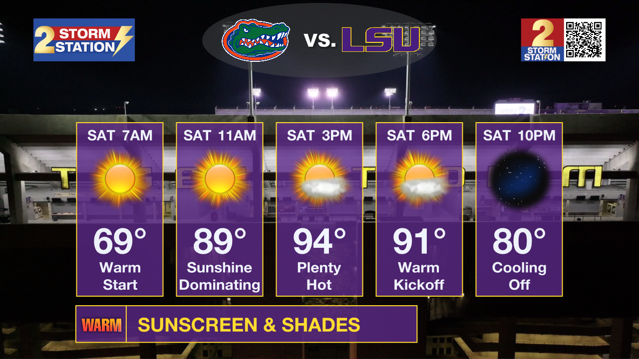
Though on the warm side, no major weather issues are expected for LSU’s big matchup with the Gators on Saturday. The same pattern of warm, slightly sticky days will carry on through next week.
Tonight & Tomorrow: Expect another mostly clear night with lows bottoming out in the upper 60s to low 70s. LSU game day will begin mild, but tailgaters will notice a sticky feel throughout the morning. Humidity levels will ease a bit to make things more tolerable during the afternoon, however. This will keep dangerous heat index values out of play. As the mugginess scales back, temperatures will peak. Highs will top out in the mid-90s across the Capital Region. Temperatures will be in the upper 80s as LSU kicks off at 6:30 p.m., falling to near 80° as the game wraps up. Rain won’t be an issue.
For those heading out to LSU, keep in mind that it is still summer. Keep hydrated given the hot and dry conditions. The sun's strength is still strong in September, meaning that it’s still easy to catch a sunburn. And with less cloud cover and humidity expected, that could allow more solar rays to get through. Have sunscreen ready to go.
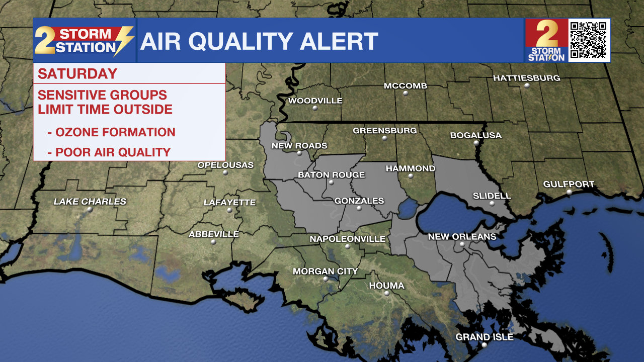
Ozone Action Day: Another Air Quality Alert has been declared on Saturday by the Louisiana Department of Environmental Quality for the Baton Rouge Metro. With little wind, plenty of sunshine, and warm temperatures, conditions will be ideal for ozone formation. Ozone levels may reach levels high enough to be problematic for those with respiratory issues such as asthma. Those individuals, as well as children and active adults, should avoid prolonged outdoor exertion.
Since pollution is a key ingredient in ozone formation, everyone can do their part to help improve air quality. Drive less, carpool, combine errands, or use a bike or walk, postpone chores that use oil-based paints or other solvents, refuel your vehicle, and mow your lawn after 6 p.m. to reduce emissions during the hottest part of the day and conserve energy at home.
Up Next: There’s not a whole lot of variety in the Storm Station 7-Day Forecast. Sunshine will dominate with afternoon highs locked in the low to mid-90s. Mornings will be mild in the upper 60s to low 70s. While humidity should stay manageable overall, the muggiest feel will come at night. Afternoons will provide a little break. There are no signs of this pattern budging at least through the end of next week, and possibly longer.
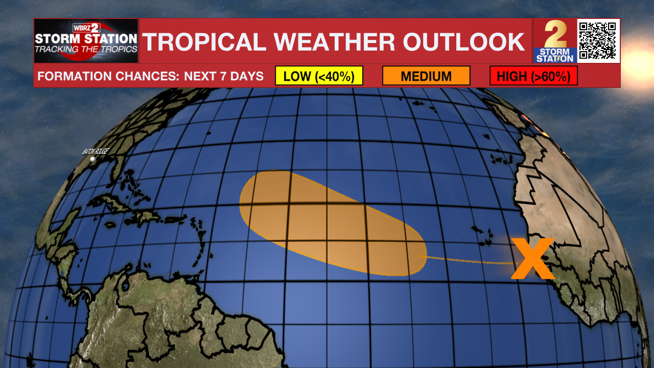
The Tropics: A tropical wave located just offshore the west coast of Africa is producing a disorganized cluster of thunderstorms. Dry and stable air will likely limit the system’s development in the coming days, but a tropical depression could form sometime next week while moving through the tropical Atlantic. There is a medium chance of development in the next week at this time. The next name up is Gabrielle.
Get the latest 7-day forecast and real-time weather updates HERE.
Watch live news HERE.
— Meteorologist Malcolm Byron
The Storm Station is here for you, on every platform. Your weather updates can be found on News 2, wbrz.com, and the WBRZ WX App on your Apple or Android device. Follow WBRZ Weather on Facebook and X for even more weather updates while you are on the go.
News
