

Latest Weather Blog
Monday Afternoon Video Forecast
Related Story
UPDATE - 1:15 p.m. Monday: Isolated storms are cropping up across the Capital Region. The Storm Prediction Center is monitoring an area just northwest of Baton Rouge for the possibility of a stronger storm or two. If it were to occur, severe weather would be incredibly spotty with gusty winds up to 60 mph being the primary concern. Widespread severe weather is not expected. Find the latest radar imagery HERE.
Dense fog could be a problem for commuters on Monday morning. Highs will stay well above normal as storm chances increase later in the week. South Louisiana continues in a much warmer-than-normal pattern to start the new week. High temperatures will climb into the 80s again on Monday, with increasing humidity and nightly fog remaining possible.

Today and tonight: A Dense Fog Advisory is in place early Monday, which could cause travel issues for the new work week. It will be warm and humid across the Capital Region with highs in the lower to middle 80s. Skies will be partly sunny, and southeast winds will continue to bring Gulf moisture into the area. Overnight lows will stay mild in the low to mid 60s. With the humid air in place, patchy fog will be possible late tonight into early Tuesday morning, especially near waterways and coastal areas. Dense fog is not expected at this time, but brief visibility reductions could occur in spots.

Use the slider to advance through the next 24 hours of Futurecast
Up Next: Temperatures remain well above normal through midweek, with Tuesday and Wednesday potentially reaching the mid-80s in some areas. This keeps the warm stretch intact as we move deeper into March.
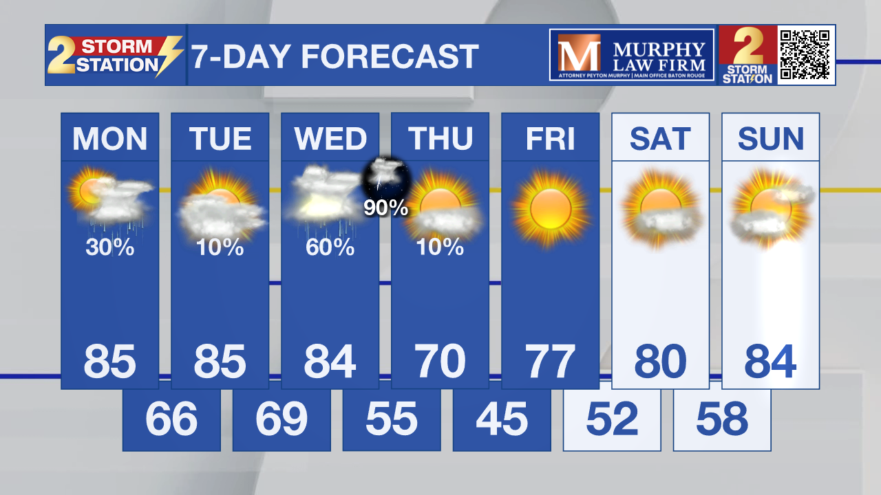
Scattered afternoon showers and thunderstorms will become more likely on Wednesday with an approaching cold front. While widespread severe weather is not expected at this time, any storms that develop could produce lightning and brief heavy rain. This could cause flooding as the grounds are saturated from weekend rainfall.
What to look out for: Nightly fog development remains possible early this week as humidity increases. Temperatures will stay 10 to 15 degrees above normal through midweek, with mid 80s possible in some locations. Storm chances increase later in the week, with sunny and cooler weather by the weekend.
Get the latest 7-day forecast and real-time weather updates HERE.
Watch live news HERE.
– Dave
The Storm Station is here for you, on every platform. Your weather updates can be found on News 2, wbrz.com, and the WBRZ WX App on your Apple or Android device. Follow WBRZ Weather on Facebook and X for even more weather updates while you are on the go.
News
