

Latest Weather Blog
Sunday morning video forecast
Related Story
Dry and cooler air settles in Sunday as a cold front moves offshore. Sunshine will gradually return, and a warm, rain-free stretch takes over for the upcoming week.
.png)
Today and tonight: Sunday starts dry as the cold front has already pushed offshore. Clouds linger early in the morning, but skies steadily clear through mid to late morning as drier air moves in. Afternoon temperatures will rise into the mid 60s — near normal for early January. If clouds hang on longer, highs will be slightly cooler.

Use the slider to advance through the next 24 hours of Futurecast
Tonight remains quiet with mostly clear to partly cloudy skies. Winds ease and temperatures fall into the 40s and 50s.
Up Next: Any cooling is short-lived. Upper-level ridging builds in quickly, allowing temperatures to rebound starting Monday. Highs return to near 70 early in the week and climb well into the 70s by Tuesday and Wednesday.
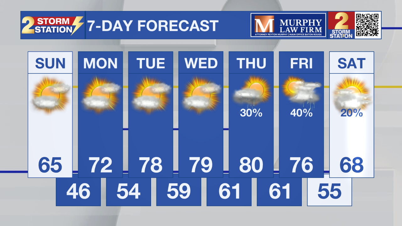
Dry weather is expected through early Thursday, with no meaningful rain chances during that time. Several afternoons during the midweek could run well above normal for early January. Better chances for rain Friday and the weekend, with a few storms possible.
What to look out for: Marine conditions remain hazardous early Sunday morning due to lingering gusty winds, especially for small craft, but conditions improve later in the day. Otherwise, forecast confidence is high with quiet weather and warming temperatures dominating the week ahead.
Get the latest 7-day forecast and real-time weather updates HERE.
Watch live news HERE.
– Dave
The Storm Station is here for you, on every platform. Your weather updates can be found on News 2, wbrz.com, and the WBRZ WX App on your Apple or Android device. Follow WBRZ Weather on Facebook and X for even more weather updates while you are on the go.
News
