

Latest Weather Blog
Sunday Night Video Forecast
Related Story
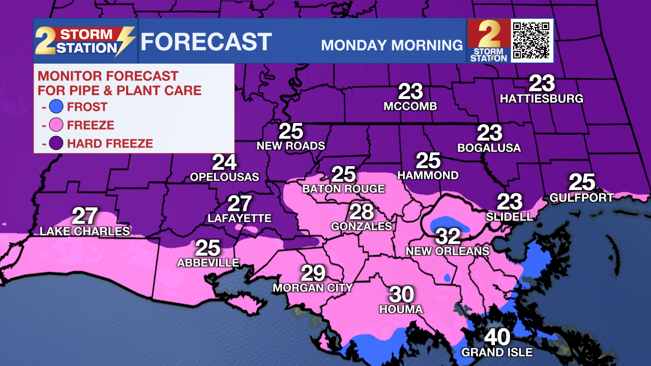
A COLD WEATHER ADVISORY will be in effect from 9 p.m. Sunday through 9 a.m. Monday for the entire region. This means that temperatures or wind chills will drop low to pose a risk of hypothermia if proper precautions aren’t taken. Morning lows will fall into the mid-20s for much of the Capital Area, and a light breeze will make it feel even colder early Monday. Wind chills will dip into the teens to near 20° along and north of I-10/I-12, while areas farther south will feel closer to 20–25°. Be sure to protect all 4 P’s Sunday night into Monday morning:
People: Bundle up before stepping outside. Wear appropriate clothing, including a heavy coat, hat, and gloves. Also, ensure that portable space heaters are used properly; keep them away from flammable materials and never leave them unattended.
Pets: What feels cold to a human also feels cold to animals. Keep pets indoors as much as possible.
Plants: With temperatures dropping below 28° for several hours in many areas, conditions will be cold enough to damage or kill most plants. Cover sensitive vegetation or bring plants indoors.
Pipes: Areas near the Mississippi River and along/north of I-10 stand the best chance of experiencing a hard freeze (28° or lower for a few hours). Exposed outdoor plumbing should be wrapped before Sunday night. A slow drip from faucets and hose connections can help prevent freezing, and opening cabinet doors allows warmer air to circulate around indoor pipes.
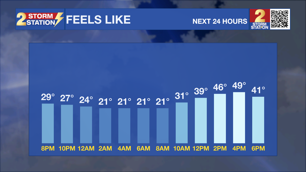
Tonight & Tomorrow: A brisk north wind will continue driving a frigid air mass into the region through the night. By daybreak, temperatures will be in the 20s across most of south Louisiana. Although the wind will gradually ease overnight, a breeze will persist, keeping wind chills near 20° in Baton Rouge, with a few locations possibly dropping into the teens. Heavy coats will be necessary for adults heading to work and children waiting at the bus stop. Keep the extra layer for the afternoon as well. Highs will top out in the 40s for many, perhaps reaching 50° in lucky neighborhoods under full sunshine. A light breeze will likely make it feel a few degrees colder than the actual air temperature, even during the day.
Up Next: Though technically warmer, many will face a near-freezing start on Tuesday, with Baton Rouge bottoming out near 30°. Thereafter, a rapid warmup will take place. Look for a high in the low 60s on Tuesday with increasing clouds. By Wednesday and Thursday, temperatures will approach and eventually exceed 70°, while returning moisture may bring occasional light showers.
There is now a signal for another cold front passage late Thursday, which could ring out a handful of thunderstorms. Storms should clear before dawn Friday, bringing a brief cooldown with highs returning to the 60s. That said, expect another fast temperature over the weekend with highs jumping in the 70s with settling near 60°. Those well-above-average temperatures are likely to persist right into Christmas week.

Get the latest 7-day forecast and real-time weather updates HERE.
Watch live news HERE.
— Meteorologist Malcolm Byron
The Storm Station is here for you, on every platform. Your weather updates can be found on News 2, wbrz.com, and the WBRZ WX App on your Apple or Android device. Follow WBRZ Weather on Facebook and X for even more weather updates while you are on the go.
News
