

Latest Weather Blog
Monday AM Forecast: Dangerous heat to start the week, Stormier pattern returns by midweek
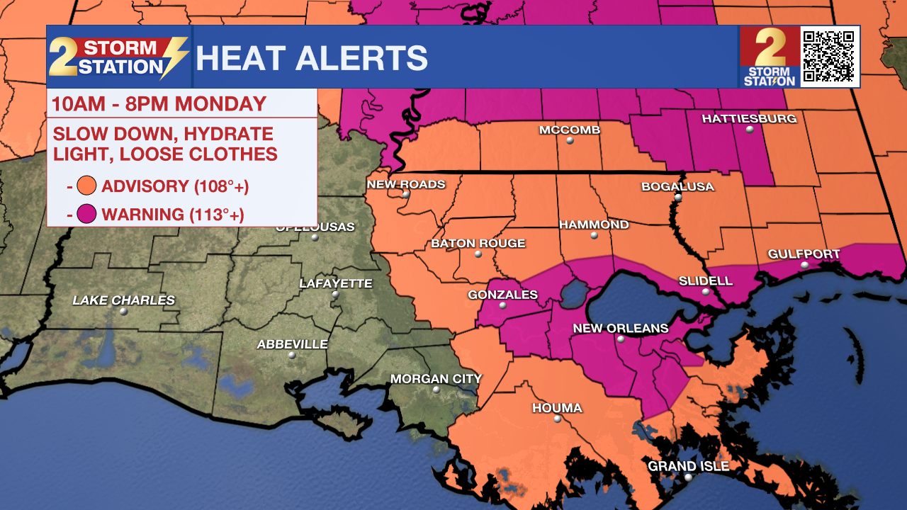
More heat alerts will be in effect from 10 a.m. to 8 p.m. Monday across the Capital Area. Most of southeast Louisiana is under a Heat Advisory, with feels-like temperatures between 105° and 110°. Areas closer to Lake Pontchartrain are under an Extreme Heat Warning, where the heat index could reach as high as 113° due to extra humidity. No matter the alert level, this kind of heat and humidity can be dangerous—especially if you're not staying hydrated or you're doing strenuous activities outside. The advisory is a strong reminder to drink plenty of water and take breaks during the hottest part of the day.
Today & Tomorrow: Heat takes center stage to kick off the workweek as a strong ridge of high pressure settles in. This system will keep rain chances very low, allowing for lots of sunshine and dangerously hot temperatures. In Baton Rouge, highs on Monday and Tuesday will climb to around 97°, with humidity pushing the heat index well into the triple digits for much of the day. Don’t count on any cooling showers, so be sure to pace yourself outdoors. Nights will stay warm and muggy, with lows only dipping into the 70s.
Up Next: Just like the last couple of weeks, the forecast turns stormier toward the end of the week. By Wednesday, high pressure will shift west, allowing tropical moisture and upper-level energy to return—setting the stage for daily thunderstorms. Expect a few isolated showers early Wednesday, followed by a scattering of more intense storms in the afternoon. This pattern of mainly afternoon storms will continue through Friday, thanks to above-average moisture levels. That means the potential for heavy downpours and an occasional strong storm. Even with added clouds and rain chances, temperatures will still reach the low 90s each day before storms develop. Looking ahead to the first weekend of August, rain chances stay elevated as tropical moisture lingers. 1 to 3 inches of rain is possible over the next 7 days. That’s generally manageable, but localized heavy rain could lead to isolated trouble spots at times.
The Tropics: No tropical development is expected in the next seven days across the North Atlantic, Caribbean Sea, and Gulf.
Get the latest 7-day forecast and real-time weather updates HERE.
Trending News
Watch live news HERE.
— Emma Kate C.
The Storm Station is here for you, on every platform. Your weather updates can be found on News 2, wbrz.com, and the WBRZ WX App on your Apple or Android device. Follow WBRZ Weather on Facebook and X for even more weather updates while you are on the go.
More News
