

Latest Weather Blog
Monday AM Forecast: Warm and dry end to April, Watching end of week storm chances
The final days of April will be very warm, with a few afternoons challenging record temperatures. By the start of May, daily thunderstorm chances are expected to return as a front moves towards the region.
Today & Tonight: Mild morning conditions with a few patchy areas of fog will quickly turn warm under mostly sunny skies. For April 28th, 90 degrees is the current record high temperature, tied most recently in 2021. The Capital City may meet or beat that record again today. Overnight, cloud cover will increase, limiting overnight lows to the upper-60s.
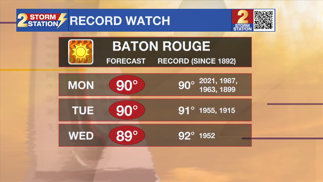
Up Next: Near-record heat will continue Tuesday and Wednesday as sunny and dry conditions prevail. Expect mornings in the upper-60s and afternoons close to 90 degrees as an upper-level ridge controls much of the southeast U.S.. The ridge will begin to break down later this week as a front dives south. A few disturbances will pass through the atmosphere from Thursday to Saturday, bringing back storm chances to the Capital Region. A better idea of exact timing and intensity of the storms will come into view in the coming days.
River Flooding: The National Weather Service has issued a RIVER FLOOD WARNING for the Mississippi River at Red River Landing, Baton Rouge, Donaldsonville, and Reserve, as well as the Atchafalaya River at Morgan City until further notice.
Trending News
• At Red River Landing, flood stage is at 48 feet. Moderate flooding is already occurring. A crest of 59.8 feet is expected on Wednesday. At this level, the east bank levee will be topped, and the prison farmland between the two levees will be inundated. Angola Landing will be under water, closing the ferry there. All river islands along the reach from Red River Landing to Baton Rouge will remain inundated with recreational camps and river bottom farmland under water. This gauge will fall below flood stage around May 14.
• At Baton Rouge, flood stage is 35 feet. At 7:00 PM CDT Sunday the stage was 42.0 feet. A crest at 42.5 feet expected on Thursday. Around these levels, the grounds of the older part of Louisiana State University's campus become soggy. This includes the area around the Veterinary Medicine building, the Veterinary Medicine Annex, and Alex Box Stadium. Levees protect the city of Baton Rouge and the main LSU campus at this level. Caution is urged when walking near riverbanks. This gauge will fall below flood stage around May 12.

• At Donaldsonville, the flood stage is at 27 feet. At 7:00 PM CDT Sunday the stage was 30.7 feet. Moderate flooding with a crest of 31.2 feet is expected around May 1. Around these levels, navigation becomes difficult for smaller river craft. Safety precautions for river traffic are urged. After cresting, the river will fall below flood stage around May 10.
• At Reserve, flood stage is at 22 feet. Minor flooding is already occurring. A crest of 23.8 feet is expected on Thursday. Around these levels, slow-bell procedures will be enacted for river transportation. After cresting, the river will fall below flood stage around May 9.
• At Morgan City, flood stage is at 6 feet and as of Sunday evening the river levels sat around 6.1 feet. Moderate flooding with a crest of 7 feet is forecast on Saturday May 3rd. At 7 feet, buildings at the foot of Ann Street on the riverside of the flood wall will flood as water overtops the Rio Oil Company dock. Buildings on the riverside of the Berwick floodwall will flood. River traffic restrictions will be strictly enforced. In addition, backwater flooding could potentially impact portions of areas around Lake Palourde and Stephensville. It will fall below flood stage on Sunday May 11th.
Get the latest 7-day forecast and real-time weather updates HERE.
Watch live news HERE.
- Emma Kate C.
The Storm Station is here for you, on every platform. Your weather updates can be found on News 2, wbrz.com, and the WBRZ WX App on your Apple or Android device. Follow WBRZ Weather on Facebook and X for even more weather updates while you are on the go.
More News
