

Latest Weather Blog
Monday PM Forecast: Cold front working south, temperatures set to plunge
Despite a cold front arriving Monday night, it will take some time to get it to cleanly pass through. But once it goes, expect a significant drop in temperatures. Jackets and/or coats will be needed on some mornings.
Tonight & Tomorrow: A cold front will arrive during the evening hours, but without the necessary momentum to cleanly pass through the region. For areas south of the front, overnight lows will struggle to drop below 70°. Meanwhile, areas north will easily dip into the 60s. It will be a close call for Baton Rouge, which is why the Storm Station forecast splits the difference and calls for a low in the mid-60s. With a front nearby and temperatures cooling close to the dew point, patches of low clouds will develop overnight. It will be partly cloudy on average. For those hoping to catch a glimpse of a comet in the early evening sky, there should be gaps within the cloud coverage.
The front mentioned above will stall out in the capital area on Tuesday. It might even drift north into the afternoon. Cooler and drier air will sit north of the boundary, vice versa for areas south. Know that Tuesday has the potential to be a warm and muggy day. Should your town find itself north of the front, you'll get a head start on experiencing cooler weather. That is on the table for areas north of Baton Rouge and into southern Mississippi.
Up Next: On Tuesday night, the cold front finally gathers enough momentum to plunge southward toward the coast. Chilly air typical of fall will quickly arrive. Baton Rouge will dip into the low-50s early Wednesday with a daytime high only rebounding into the mid-70s. Morning lows get even colder on Thursday with Baton Rouge getting into the mid-40s. Even cooler temperatures are possible outside of the city. But it won't last forever, temperatures gradually climb into the weekend. But even then, it looks comfortable with little to no rain in sight.
Get the latest 7-day forecast and real time weather updates HERE.
Trending News
Watch live news HERE.
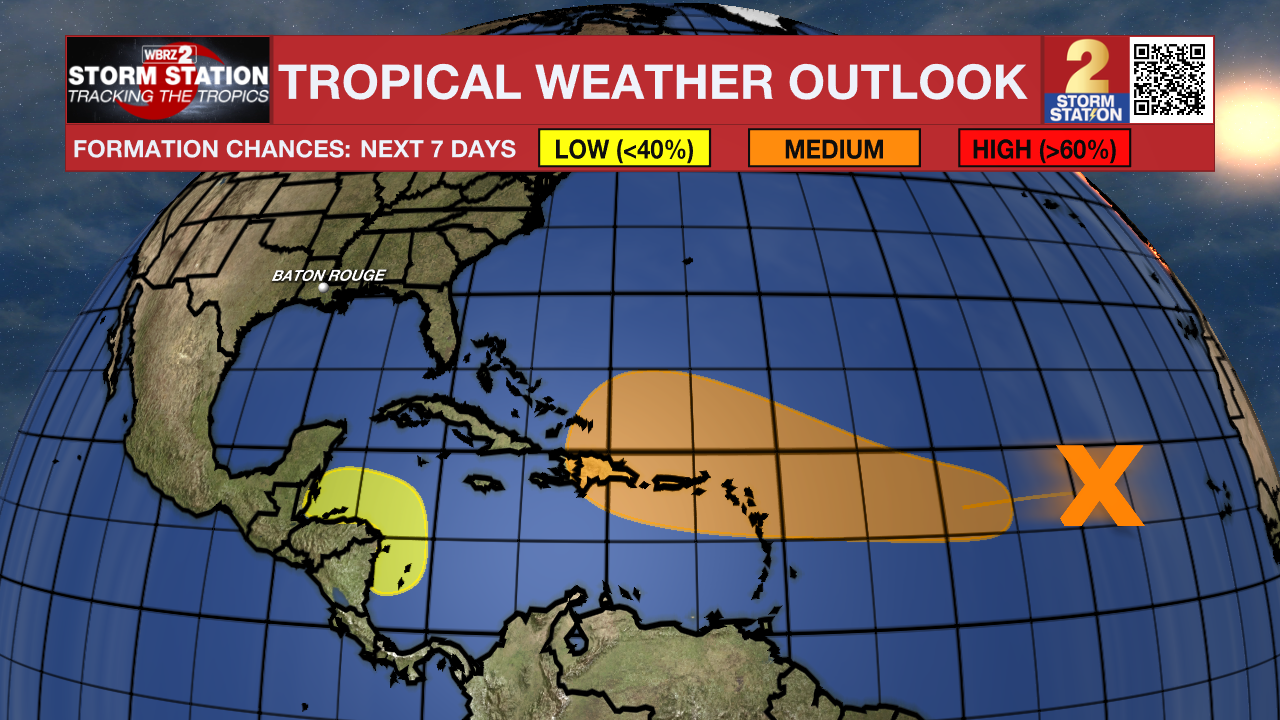
The Tropics: A well-defined area of low pressure located midway between the Cabo Verde Islands and the Lesser Antilles is producing a few showers and thunderstorms. The system is currently sitting in a dry environment. Thus, further development is unlikely in the coming days. However, the system will encounter warmer waters by the middle to latter part of the week as it nears the Leeward Island chain. A tropical depression could form around that time.
A broad region of disturbed weather is likely to form over the southwestern Caribbean Sea by the middle to latter portions of the week. Some development is possible thereafter if the system stays over water while moving slowly toward Central America. Regardless of tropical development, locally heavy rainfall is possible across portions of Central America later in the week.
-- Meteorologist Malcolm Byron
The Storm Station is here for you, on every platform. Your weather updates can be found on News 2, wbrz.com, and the WBRZ WX App on your Apple or Android device. Follow WBRZ Weather on Facebook and Twitter for even more weather updates while you are on the go.
More News
