

Latest Weather Blog
Monday PM Forecast: Gearing up for a breezy fall chill
The first true fall front of the season is expected to move through by midweek. A breezy northwest wind behind it will usher in a significantly cooler air mass — just in time for Halloween.
Tonight & Tomorrow: Mostly clear skies will continue overnight, with comfortably cool lows in the upper 50s to low 60s. A few patches of fog may develop for the morning commute, but widespread fog is not expected. Tuesday will be mostly sunny and still on the warm side, with highs reaching the low 80s. Clouds will begin to build during the evening ahead of an approaching cold front. As it arrives, scattered showers and storms will move through from west to east. These will not be significant rainmakers. Affected areas will pick up less than a quarter-inch of rain, and a few spots may miss the showers altogether.
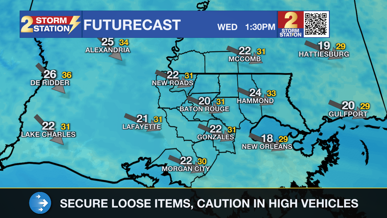
Up Next: Behind the front, a brisk northwest wind kicks into high gear. It will be noticeable on Wednesday, with sustained wind speeds at 15 to 25 mph and gusts upwards of 35 mph. There’s a decent chance of a Wind Advisory being issued at some point, so it might be a good idea to secure loose outdoor items like Halloween decorations ahead of time. The wind will also drive a fall chill into the area, with highs struggling to top the mid-60s on Wednesday and Thursday. Meanwhile, lows will settle in the 40s to wrap up the week.
Halloween & The Weekend: After highs in the upper 60s to near 70°, trick-or-treaters can expect temperatures in the low to mid-60s early in the evening. By the time the festivities wrap up, readings will have dipped into the 50s. Consider adding an extra layer to costumes this year. Temperatures will creep up a bit over the weekend, but it’ll still feel like fall. Rain doesn’t look to be an issue from Halloween through the weekend.

The Tropics: Hurricane Melissa is a powerful Category 5 hurricane in the Caribbean as of Monday afternoon. The core of the storm will make landfall in Jamaica by Tuesday, still as a Category 5 storm. That would be the strongest hurricane on record to ever directly strike Jamaica. Catastrophic and life-threatening winds, flooding, and storm surge are expected on the island. After landfall, the storm will accelerate northeastward and affect Cuba, the Turks and Caicos, and eventually the Bahamas. The National Hurricane Center notes the following.
Trending News
Jamaica: Do not venture out of your safe shelter. Catastrophic and life-threatening flash flooding and numerous landslides are likely today through Tuesday. Catastrophic winds in the eyewall have the potential to cause total structural failure, especially in higher elevation areas tonight and early Tuesday. This will result in extensive infrastructural damage, long-lasting power and communication outages, and isolated communities. Life-threatening storm surge and damaging waves are expected along the southern coast through Tuesday.
Haiti and the Dominican Republic: Catastrophic and life-threatening flash flooding and landslides are expected across southwestern Haiti and southern portions of the Dominican Republic through midweek. In Haiti, extensive infrastructural damage and isolation of communities are likely. Tropical storm conditions are expected late Tuesday and Wednesday.
Eastern Cuba: Heavy rainfall with life-threatening and potentially catastrophic flash flooding and landslides is expected beginning today. Life-threatening storm surge and damaging winds are expected late Tuesday and Tuesday night. Preparations should be rushed to completion.
Southeast Bahamas and the Turks and Caicos: Hurricane conditions, life-threatening storm surge, and heavy rainfall are possible on Wednesday. Residents should follow advice given by local officials and be sure to have preparations complete by Tuesday night.
Get the latest 7-day forecast and real-time weather updates HERE.
Watch live news HERE.
— Meteorologist Malcolm Byron
The Storm Station is here for you, on every platform. Your weather updates can be found on News 2, wbrz.com, and the WBRZ WX App on your Apple or Android device. Follow WBRZ Weather on Facebook and X for even more weather updates while you are on the go.
More News
