

Latest Weather Blog
Saturday AM Forecast: Pleasant spring weather ahead, Mississippi river steadily rises
The weather this past week has been exceptional, and those same conditions will continue into the weekend. Eyes are still on the Mississippi river, which continues to steadily rise.
Today & Tonight: After a chilly morning start in the upper 40s, temperatures will rise into the middle 70s by the afternoon and evening. No rain is in the forecast, with sunshine dominating all day long. Given all the sunshine, make sure to wear sunscreen, as sunburns will set in very quickly. In the overnight hours, it will be cool/chilly once again, with lows near 50 degrees.
Up Next: Highs will trend warmer for the 2nd half of the weekend, into the low 80s. Thankfully, humidity will continue to not be a factor.
Nice weather conditions will stick around into next week. The main feature the Storm Station is tracking, is a weak front expected to pass Tuesday. Moisture looks limited, so only expect some spotty showers, and more clouds in the area. The front will have little effect on temperatures. Each day will feature a high in the upper-70s to low-80s with mild overnight lows in the 50s and 60s. Overall, the amazing spring weather conditions will continue, with no major rainmaker forecasted in the next 7 days!
River Flooding: The National Weather Service has issued a RIVER FLOOD WARNING for the Mississippi River at Red River Landing until further notice. A RIVER FLOOD WARNING will go into effect late Monday for the Mississippi River at Baton Rouge.
Trending News
• At Red River Landing, flood stage is at 48 feet. Minor flooding is forecast by Friday evening. Moderate flooding is expected with a crest near 57 feet on April 23. Around these levels, Angola farmland on the left bank begins taking on water. Caution is urged when walking near riverbanks.
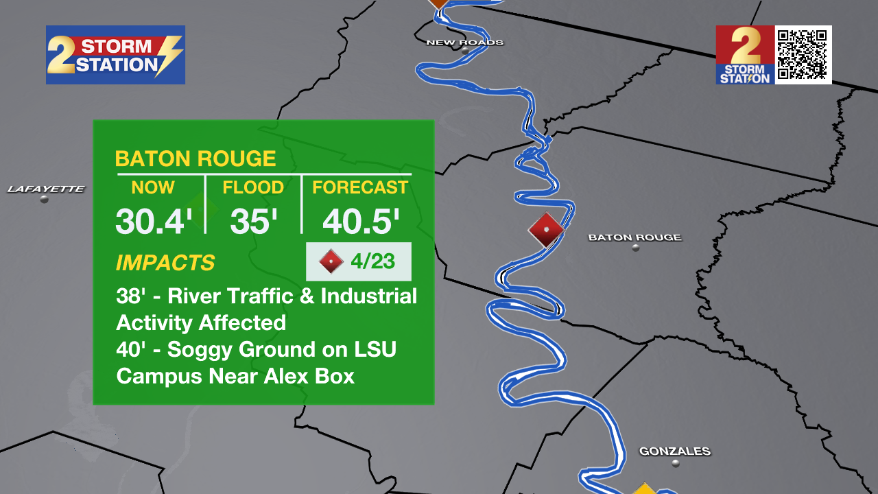
• At Baton Rouge, flood stage is 35 feet. Minor flooding is forecast to begin early Tuesday, cresting just above major flood stage on April 23 with a height of 40.5 feet. Levels will fall below flood stage around May 2. Around these levels, the grounds of the older part of Louisiana State University's campus become soggy. This includes the area around the Veterinary Medicine building, the Veterinary Medicine Annex, and Alex Box Stadium. Levees protect the city of Baton Rouge and the main LSU campus at this level. Caution is urged when walking near riverbanks.
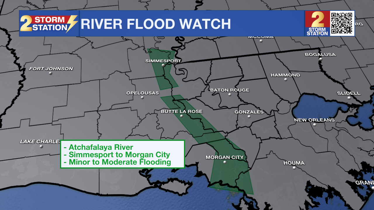
The National Weather Service has issued a RIVER FLOOD WATCH for the Atchafalaya River at Simmesport, Butte La Rose, and Morgan City until further notice.
• At Simmesport, flood stage of 40 feet may be reached by April 24. There will be flooding of areas inside the levees of the Atchafalaya Floodway and considerable flooding in the backwater storage area in Avoyelles Parish.
• At Butte La Rose, flood stage of 20 feet may be reached by April 24. Minor flooding of the nearby areas could occur.
• At Morgan City, flood stage of 6 feet may be reached by April 19. Moderate flooding at 7 feet is forecast by April 23. At 7 feet, buildings at the foot of Ann Street on the river side of the flood wall will flood as water overtops the Rio Oil Company dock. Buildings on the river side of the Berwick floodwall will flood. River traffic restrictions will be strictly enforced. In addition, backwater flooding could potentially impact portions of areas around Lake Palourde and Stephensville.
Get the latest 7-day forecast and real-time weather updates HERE.
Watch live news HERE.
-- Balin
The Storm Station is here for you, on every platform. Your weather updates can be found on News 2, wbrz.com, and the WBRZ WX App on your Apple or Android device. Follow WBRZ Weather on Facebook and X for even more weather updates while you are on the go.
More News
