

Latest Weather Blog
Sunday PM Forecast: Heat hanging on ahead of another stormy stretch
Another HEAT ADVISORY will be in effect from 10 a.m. to 8 p.m. Monday across the Capital Area. The heat index, or how hot it actually feels when you factor in humidity, will peak between 105° and 110° for most. Some spots could even feel closer to 112°. Such a mixture of heat and humidity could lead to heat-related illnesses, especially without proper hydration during strenuous activities. The advisory merely serves as a reminder to drink plenty of fluids and take it easy during the hottest parts of the day.
Tonight & Tomorrow: Spotty pop-up storms from the afternoon will fizzle out quickly on Sunday evening. The rest of the night will be mostly clear and muggy with an overnight low in the mid 70s. A dominant ridge of high pressure will sit overhead on Monday, making heat the primary focus. Baton Rouge should hit a high temperature of 97°, which would be the hottest temperature so far this year. Paired with humidity, feels-like temperatures will run several degrees hotter — enough to warrant a Heat Advisory (see above). The odds of coming across a brief shower are so slim that it’s hardly worth mentioning. The ridge will help to shut down storm development in most cases.
Up Next: High heat will linger into Tuesday, with many spots reaching the mid to upper 90s again. However, a shift toward a wetter pattern will begin as another push of tropical moisture moves in. This will open the door for hit-or-miss storm activity during the day. The timing of this moisture return will play a role in the temperature forecast; forecast adjustments may be needed in the next day or so.
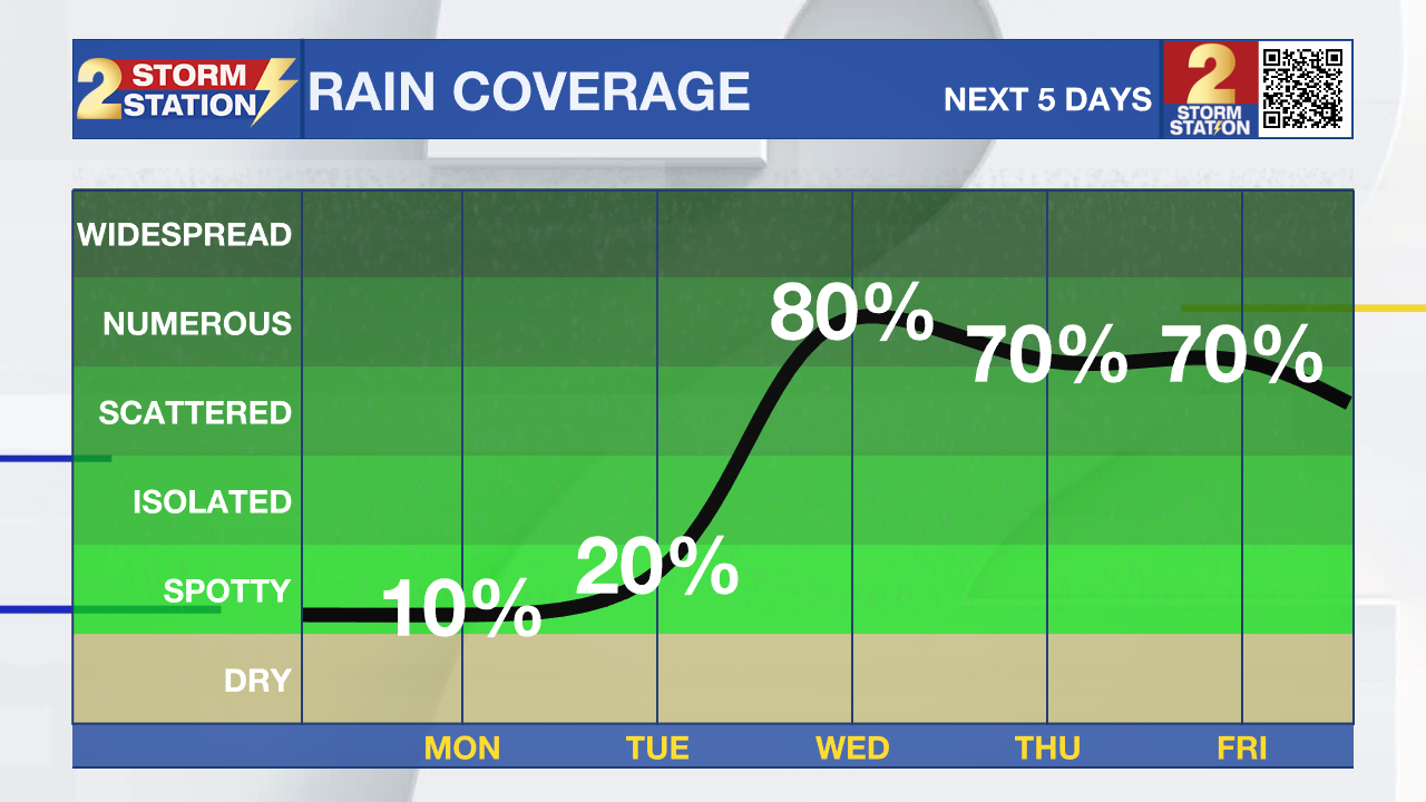
By Wednesday, moisture won’t be in short supply. An incoming disturbance will act on it to excite numerous showers and thunderstorms. And that’s just the beginning of another stormy stretch. Lingering moisture will support daily rounds of thunderstorms all the way through next weekend. Timing details will become clearer with time, but no day looks like a washout. Roughly 1-3” of rain is expected during the next week across south Louisiana. That’s manageable, but locally heavy rain could result in a few trouble spots on occasion.
The Tropics: No tropical development is expected in the next seven days across the North Atlantic, Caribbean Sea, and Gulf.
Trending News
Get the latest 7-day forecast and real-time weather updates HERE.
Watch live news HERE.
— Meteorologist Malcolm Byron
The Storm Station is here for you, on every platform. Your weather updates can be found on News 2, wbrz.com, and the WBRZ WX App on your Apple or Android device. Follow WBRZ Weather on Facebook and X for even more weather updates while you are on the go.
More News
