

Latest Weather Blog
Sunday PM Forecast: Weak front holding its ground, tropics awakening
A stalled front will linger on Monday, bringing a slight dip in humidity and storm chances for parts of the area. By midweek, the routine summer pattern full of heat and steam returns.
Tonight & Tomorrow: Overnight lows will be seasonable for early August, reaching the lower and middle 70s under a mostly clear sky. How Monday unfolds will depend on the position of a weak front that settled into the area over the weekend. An incoming disturbance will likely keep that front stalled near or southeast of the Capital Area. That would keep much of the area on the “dry” side of the boundary, aided by a northerly wind. The main impact of this is a lower chance of rain, but some locations might benefit from a slight improvement in humidity. Affected areas will still be muggy, but at least it’s a break from the extreme summer steam.
Communities near the tidal lakes or coast will find themselves closer to the front, where more humid conditions reside. It is in these locations where a spotty shower or storm is favored during the heat of the day. Every location will be warm temperature-wise. Look for a high in the low to mid-90s across Metro Baton Rouge, whereas more humid eastern sections may end up a degree or two cooler.
Up Next: As the dog days of summer continue, so do the heat and steam. Summer-like humidity returns for everybody Tuesday onward, with highs in the low to mid 90s. Afternoon pop-up storms look to be a near-daily occurrence. While a few passing disturbances may excite a greater number of storms on occasion, the atmosphere looks fairly moisture-starved. That should limit rain coverage even on the most active days.
The Tropics: Tropical Storm Dexter formed on Sunday evening in the subtropical Atlantic. While the system had produced tropical storm-force winds for some time, it was attached to a frontal system. The storm will move east and northeastward in the coming days, posing no threat to land. Since Dexter will be moving into cooler waters, there will only be a brief window for intensification. Dexter will likely be post-tropical by midweek.
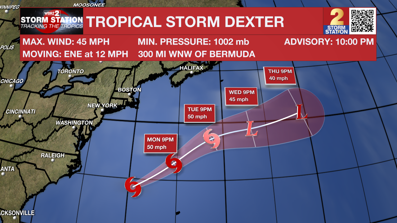
There are also a few other areas the Storm Station and National Hurricane Center are keeping an eye on:
Trending News
Off the Southeast U.S. - An area of low pressure may form in a few days a few hundred miles southeast of the Carolinas. Gradual development of the system is possible by midweek as the system meanders northwest. Tropical formation odds are low at this time. This system does not appear to be a threat to Louisiana.
Central Tropical Atlantic - A tropical wave is moving off the west coast of Africa. Thereafter, gradual development of the wave is possible. A tropical depression could form late this week while the system moves west-northwestward across the tropical Atlantic.
Get the latest 7-day forecast and real-time weather updates HERE.
Watch live news HERE.
— Meteorologist Malcolm Byron
The Storm Station is here for you, on every platform. Your weather updates can be found on News 2, wbrz.com, and the WBRZ WX App on your Apple or Android device. Follow WBRZ Weather on Facebook and X for even more weather updates while you are on the go.
More News
