

Latest Weather Blog
Tuesday PM Forecast: incoming stretch of stormy weather could threaten outdoor events
Warm and dry weather will hang around the Baton Rouge Area for one more quiet day on Wednesday before the atmosphere undergoes a major shift to end the week and month. A surge of tropical moisture will interact with a slow-moving front to trigger daily rounds of showers and thunderstorms and a threat of nuisance flooding.

Summer’s Last Gasp: warm and sunny, creeping humidity on Wednesday
Stormy Transition: surge of moisture, increasing rain Thursday onward
Watching Weekend Plans: rounds of thunderstorms could complication outdoor events, football games
Trending News
Tonight and Tomorrow: Expect mostly clear skies tonight with overnight temperatures dipping into the low 70s. Feel free to leave the rain gear tucked away for one more day. The atmosphere will remain warm and dry on Wednesday allowing a lot of sunshine and afternoon temperatures in the low 90s.
Up Next: Starting Thursday, humidity will pour back into the region both at the surface and deep into the atmosphere. With this fuel for rain, as afternoon highs hit the low 90s, scattered showers and thunderstorms will pop.
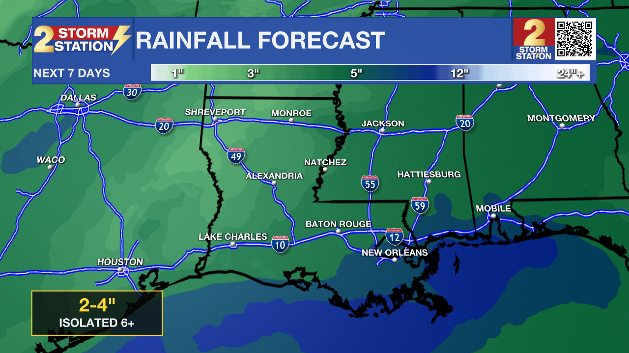
By Friday and into the weekend, weather conditions could turn even more active. A tropical wave moving northwest out of the Caribbean will team up with a slow-moving cold front pushing in from the west. As these features converge, a metric called precipitable water, which tells how much moisture is in the atmosphere, will be near record values for early October. In total, this all means some locations could experience very heavy rain at times Friday through Sunday. While it is still too early for hour-by-hour specifics, including high school and college football games, here are some early takeaways:
• Rain Coverage: Rain coverage jumps to 60% on Friday, Saturday, and Sunday meaning many locations will get rain at some point each day, a few spots could miss out.
• Rain Totals & Impacts: Most of the Capital Area can expect 3 to 6 inches of rain between Friday and Sunday. However, intense rainfall rates could top 4 inches per hour in small point locations during thunderstorms. Rain coming down that fast would easily overwhelm street storm drains and ditches, leading to water ponding on roads and localized flash flooding in low-lying spots or underpasses. Local rivers and bayous are currently very low, meaning they have plenty of room to absorb runoff.
• Temperatures: Highs will gradually cool due to cloud cover and rain, dropping into the 80s rather than the 90. Lows will hold steady in the low 70s due to humidity.
The unsettled pattern is expected to back down gradually next week. A stronger cold front is possible just after the scope of the Storm Station 7-Day Forecast that could bring the first big temperature drop of the season.
Get the latest 7-day forecast and real-time weather updates HERE.
Watch live news HERE.

The Tropics: While tropical moisture is heading our way, the two organized tropical systems out in the open Atlantic will stay far away from the Gulf Coast. Tropical Storm Hanna is out in the central subtropical Atlantic, over 1,000 miles east-northeast of Bermuda. Hanna is moving southeast at 12 mph with 40 mph sustained winds and will gradually weaken over open water into a post-tropical system without posing any threat to land.
– Josh
The Storm Station is here for you, on every platform. Your weather updates can be found on News 2, wbrz.com, and the WBRZ WX App on your Apple or Android device. Follow WBRZ Weather on Facebook and X for even more weather updates while you are on the go.
More News

