

Latest Weather Blog
Tuesday PM Forecast: tracking a front and much drier conditions for the end of the week
Unseasonably high heat and steam will continue through Wednesday. However, a cold front will usher in some significant changes to the outside feel ahead of the weekend.
-Wednesday: steamy with spotty showers and thunderstorms
-Rest of Workweek: turning drier, mainly clear skies
-Weekend: coolest mornings so far this season, lots of sun
Tonight & Tomorrow: Overnight, lows will settle near 71 degrees, with fog once again possible, though the threat for dense fog should be lower than last night. Wednesday will keep its summer feel with heat in the upper 80s and humidity pushing feels-like temperatures into the 90s, but that pattern is about to change. A cold front pushing through Wednesday night could trigger spotty showers and thunderstorms during the afternoon, but this should be a case when most locations miss rain.
Up Next: Beyond the front, afternoon highs will only dip slightly, staying in the mid to upper 80s —which is just a touch above average for early October. However, the mornings will feel different as lower humidity allows morning lows to slide into the 60s. Mainly clear skies will prevail Thursday through the weekend. In fact, by the weekend, enough dry air could be in place for some spots north of the interstates to visit the upper 50s for the first time this fall season. The pleasant, dry pattern should hold into early next week with highs continuing in the mid-80s and lows near 60.
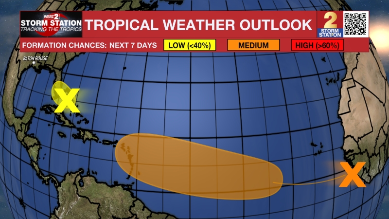
The Tropics: Tropical Storm Jerry has formed over the central Atlantic, becoming the tenth named storm of the season. As of Tuesday, Jerry was about 1,300 miles east-southeast of the northern Leeward Islands with maximum sustained winds of 45 mph and moving quickly west at 24 mph. Jerry will slow down and turn slightly west-northwest over the next couple of days. The storm could strengthen into a hurricane by Wednesday or Thursday, with its core likely passing near or just north of the northern Leeward Islands late Thursday or Friday.
Trending News

A trough of low pressure over the Yucatan Peninsula was producing widespread but disorganized showers and thunderstorms on Tuesday. The system is expected to move into the Bay of Campeche, where some slow development is possible, before it moves inland over southern Mexico by late Wednesday or early Thursday.
Get the latest 7-day forecast and real-time weather updates HERE.
Watch live news HERE.
– Josh
The Storm Station is here for you, on every platform. Your weather updates can be found on News 2, wbrz.com, and the WBRZ WX App on your Apple or Android device. Follow WBRZ Weather on Facebook and X for even more weather updates while you are on the go.
More News
