Tuesday PM Forecast: Wet Wednesday ahead of big humidity break
The Capital Area's next impact will arrive on Wednesday in the form of showers and thunderstorms. The rain will exit late Wednesday as a cold front sweeps through the region. Relatively cooler weather will be left behind.
Tonight & Tomorrow: After rolling back into the Capital Area during the day, clouds will have some staying power Tuesday night. A surge in Gulf moisture will result in a rapid return of mugginess. Expect an overnight low near 70°, which could occur closer to midnight. By daybreak, temperatures should be in the low to mid-70s. The boost in moisture will also open the door for isolated showers to enter the mix. That will be in addition to patchy sprinkles that linger into the night.
An ample amount of moisture paired with an approaching upper-level disturbance will result in even more showers and storms on Wednesday. Rain coverage looks to steadily increase as the morning progresses, with scattered activity around into the afternoon. Wednesday will be another day to have the rain gear ready to go. The day will not be a washout, but the majority should pick up something measurable at some point (up to 1" on average, locally higher). Flooding looks to be a lesser concern, but isolated instances standing water are not off the table. A damaging wind gust or brief spin-up tornado also cannot be ruled out. But that will be the exception as opposed to the rule; major severe weather issues are not expected. It will be warm and muggy with a high in the low-80s.
Up Next: Rain exits late Wednesday, leaving behind a drier picture for the rest of the week. A cold front will arrive on Thursday, and a more refreshing feel will trail said front. Highs will dip into the middle-70s with lows down into the low-50s late this week and into the weekend. These numbers have come down slightly from recent updates. Early next week, both highs and lows will inch higher with each passing day. While next week starts off on a warm note, there are some early signs of a bigger fall cooldown by the end of next week. Stay tuned!
Get the latest 7-day forecast and real time weather updates HERE.
Trending News
Watch live news HERE.
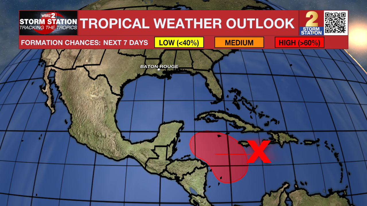
The Tropics: A disorganized region of showers and thunderstorms is located over the central Caribbean Sea. Environment conditions appear favorable for tropical development, and a tropical depression is likely to form within the next two to three days while the system moves slowly westward into the western Caribbean Sea. Afterward, further development is likely while the disturbance meanders over the western Caribbean Sea through the weekend. The system is forecast to begin moving slowly northwestward by early next week. Interests in the western and northwestern Caribbean Sea should monitor the progress of this system. For now, this system does not appear to pose a threat to Louisiana.

-- Meteorologist Malcolm Byron
The Storm Station is here for you, on every platform. Your weather updates can be found on News 2, wbrz.com, and the WBRZ WX App on your Apple or Android device. Follow WBRZ Weather on Facebook and X for even more weather updates while you are on the go.


