

Latest Weather Blog
Wednesday AM Forecast: Many extra layers needed as Arctic chill arrives
Rain exits early Wednesday and will quickly be replaced by colder air. A steady northerly breeze over the next 48 hours will add an additional chill to the already frigid conditions!
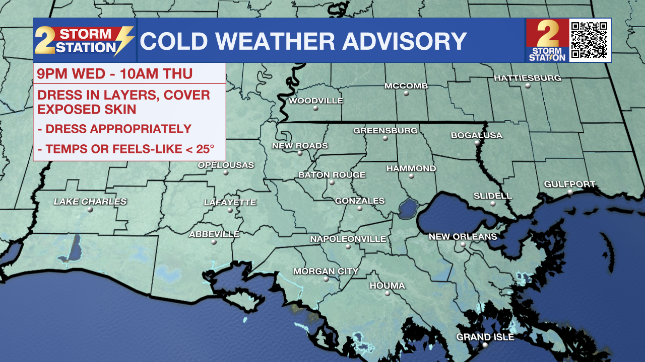
Today & Tonight: Clouds will remain behind Tuesday night's rain on Wednesday. Along with the clouds, a northerly wind at 10-20 mph with higher gusts will quickly usher in much colder air and even lower wind chills. Temperatures on Wednesday will be stuck in the 40s with feels-like conditions in the 30s. After sunset, skies will begin to clear and temperatures will quickly drop. A Cold Weather Advisory will be in effect for all of southern Louisiana from 9 pm Wednesday to 10 am Thursday as temperatures and/or feels-like conditions will be at or below 25°. Look for a morning low near 27° in Baton Rouge with a wind chill in the teens.
Up Next: Expect bitter cold mornings for the remainder of the workweek. Almost everybody will dip into the 20s on Thursday and Friday mornings. An extended period below freezing will be enough to damage or kill vegetation, especially since they’ve started to wake up during the recent warm stretch. Areas along and north of I-10/12 could see a hard freeze – which would be a problem for pipes. Wind will also be a consideration, with wind chills dropping into the teens and 20s on both mornings. An additional Cold Weather Advisory will likely be issued for Thursday night as well. Several layers will be needed when going to work or school. Daytime highs will warm into the upper-40s and low-50s.
As a reminder, starting this season, NWS has changed the cold weather alerts. You will receive different messages to highlight impacts than during previous winters. Review those changes, including the removal of Hard Freeze Warnings, HERE.
Weekend: Although temperatures will remain below average for late February this weekend, a warming trend will begin. Look for highs in the mid to upper-50s on Saturday and low to mid-60s on Sunday. Each day will feature a mix of sun & clouds. A slim chance for rain will also exist Saturday evening and overnight as another weak system could bring some light showers. By next Monday, afternoon highs will return to the 70s.
Trending News
Get the latest 7-day forecast and real-time weather updates HERE.
Watch live news HERE.
- Emma Kate C.
The Storm Station is here for you, on every platform. Your weather updates can be found on News 2, wbrz.com, and the WBRZ WX App on your Apple or Android device. Follow WBRZ Weather on Facebook and X for even more weather updates while you are on the go.
More News
