

Latest Weather Blog
Thursday morning video forecast
Related Story
Heat Advisory Day 2! Excessive Heat Warning for Friday, June 24th.
THE FORECAST
Today & Tonight: A Heat Advisory will be active from 10 a.m. to 7 p.m. today. The heat index will be between 108-112° this afternoon. Like yesterday, a few spots will get a shower or storm. Areas south of I-10 and I-12 will have a better chance to see some rain today. If you need to be outside today, take good care of yourself and drink lots of water. Temperatures tonight will not offer much relief, in the mid-70s.
Sun and Heat Safety: Some friendly reminders as the intense heat makes a comeback—sunburn can occur in less than 15 minutes with the extreme U.V. Index typical of this time of year. In addition to that, heat exhaustion and heat stroke can set in just as quickly. Seek medical attention if you or somebody you know is affected. While we all enjoy a list of cool beverages, be sure water is at least a part of that list! Finally, look before you lock. DO NOT leave people or pets in an unattended car.
.png)
Up Next: Expect a string of heat advisories or warnings for the rest of the week. Afternoon temperatures will be at least 98°, temperatures could briefly go up to 100°. That is just the air temperature! After factoring in the humidity, it will feel between 108-113° in the afternoon. Rain will be tough to come by. A stray shower will be possible almost every afternoon, but most locations will be completely dry. Rain coverage will jump up early next week. The temperatures will be capped in the low 90s early next week. Click here to see the 7-day forecast.
*EXCESSIVE HEAT WARNING* for the shaded area for Friday, June 24th. Minimize time outside. Check on kids, pets, and the elderly. Our latest forecast: https://t.co/1NFYtqf6dL pic.twitter.com/XZrnMX8HQB
— WBRZ Weather (@WBRZweather) June 23, 2022
Use the WBRZ WX App to keep tabs on the “feels like” temperatures. Hour-by-hour weather tracking is available for your location on the WBRZ WX App on your Apple or Android device. Follow WBRZ Weather on Facebook and Twitter for even more weather updates and unique weather insight from the whole team!
.png)
In the Tropics:
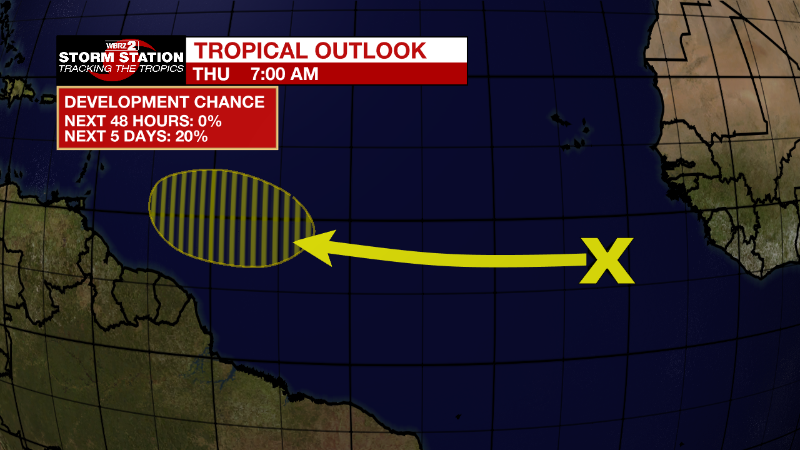
Tropical Atlantic:
A tropical wave located over the eastern tropical Atlantic is producing disorganized showers and thunderstorms. Environmental conditions could become conducive for gradual development of this system by early next week as the disturbance moves westward at around 15 mph over the tropical Atlantic.
* Formation chance through 48 hours...low...near 0 percent.
* Formation chance through 5 days...low...20 percent.
News
