

Latest Weather Blog
Monday AM Forecast: Multiple rounds of storms this week, First arrives Monday afternoon
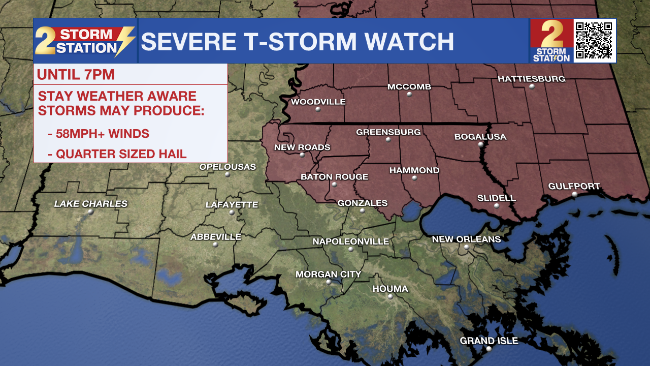
A Severe Thunderstorm Watch has been issued for East and West Baton Rouge, Pointe Coupee, East and West Feliciana, St. Helena, Livingston, and Tangipahoa parishes as well as Wilkinson and Amite Counties until 7pm Monday evening as a line of strong storms is expected to move through the Capital Area this afternoon. Storms within this line are capable of producing damaging wind gusts, up to quarter sized hail, and an isolated tornado or two.
Multiple rounds of storms will move through the Capital Area this week. When not raining, expect warm and humid air under a mix of sun and clouds.
Here’s a breakdown of the week ahead:
- Memorial Day: warm and humid, scattered afternoon storms
- Rest of the Week: multiple rounds of storms, still warm and humid
- The Weekend: trending drier, possible heat/humidity relief
Trending News
Memorial Day: Through the early afternoon hours, expect warm and humid temperatures quickly heating into the upper-80s, near 90 degrees for a high temperature, under a mix of sun and clouds. By Monday afternoon, a line of storms will approach the Capital Region from the northwest. Scattered storms are likely to move through sometime Monday afternoon, with the greatest coverage of rain along and north of the interstate. Within any of the passing storms, watch our for cloud-to-ground lightning, heavy downpours, gusty winds, and small hail. By nightfall, radar activity will quickly die down. Overnight conditions will be warm and muggy, falling near 74° in Baton Rouge.
Up Next: The next round of showers and thunderstorms will form in Texas Monday evening and push east overnight. By early Tuesday, the Capital Area may be dealing with more heavy downpours just in time for the morning commute back from a long weekend. Although the line of storms is expected to weaken as it moves through, isolated to scattered activity could impact drive times and roadway conditions early Tuesday. For those headed back to work tomorrow, don't forget to grab the raingear!
The active pattern will remain on Wednesday and Thursday as a frontal system settles into the area. Between rounds of storms this week, conditions will remain warm and steamy. Each day will see peak temperatures in the upper-80s with the same humid feel. Not all outdoor activities will be a washout, so just monitor the radar closely when outdoors.
The unsettled weather pattern will trend quieter into the weekend. A possible cool front passage by Saturday morning may even take temperatures and humidity down a bit. The exact weekend forecast will come into better view in the next few days, so keep checking back in if you have any plans for the final weekend of the month.
Get the latest 7-day forecast and real-time weather updates HERE.
Watch live news HERE.
-Emma Kate C.
The Storm Station is here for you, on every platform. Your weather updates can be found on News 2, wbrz.com, and the WBRZ WX App on your Apple or Android device. Follow WBRZ Weather on Facebook and X for even more weather updates while you are on the go.
More News
