

Latest Weather Blog
Monday AM Forecast: Stalled front limits rain today, Few areas to watch in Tropics
The first week of school for many kids across the Capital Area kicks off with typical August weather—hot, humid, and a few afternoon storms. No major weather concerns expected for drop-off or pick-up.
Today & Tonight: A front that moved through over the weekend is now stalled along the coast. This is keeping early morning rain mainly offshore. Behind the front, humidity is slightly lower, making for a more comfortable start to the day with morning temps in the upper 60s to low 70s. Highs will reach around 93° this afternoon in Baton Rouge. With the front staying south of I-10/12, skies will be mostly to partly sunny, and rain chances remain low. Overnight, the front could drift north, resulting in a slight increase in humidity. Tuesday morning temps will start in the mid-70s.
Up Next: That same front will linger near the area over the next few days. Moisture and humidity will slowly return through the workweek. As that happens, we’ll see a more typical summer pattern with a few isolated showers and storms each afternoon. Rain coverage will be around 20–30% Tuesday through Friday. Highs will reach the low 90s each day with a mix of sun and clouds—pretty normal for early August. No major weather issues are expected for back-to-school plans.
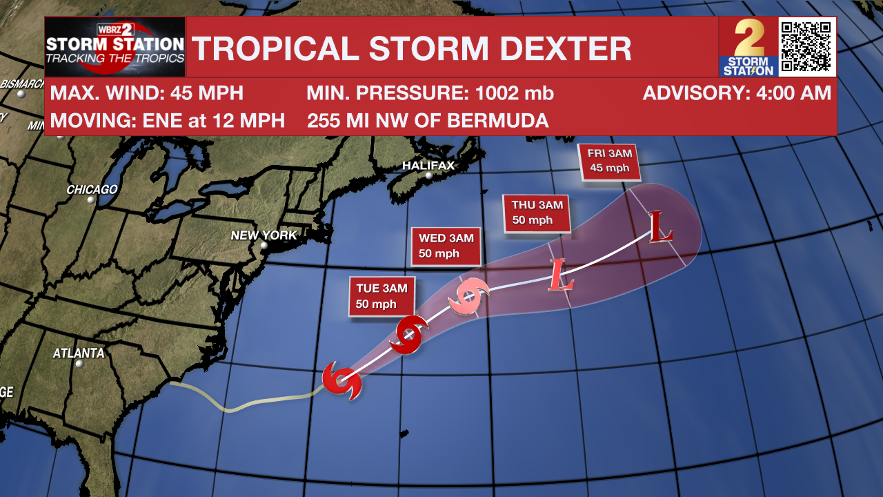
The Tropics: Tropical Storm Dexter formed on Sunday evening in the subtropical Atlantic. While the system had produced tropical storm-force winds for some time, it was attached to a frontal system. The storm will move east and northeastward in the coming days, posing no threat to land. Since Dexter will be moving into cooler waters, there will only be a brief window for intensification. Dexter will likely be post-tropical by midweek.
There are also a few other areas the Storm Station and National Hurricane Center are keeping an eye on:
Off the Southeast U.S. - An area of low pressure may form in a few days, a few hundred miles southeast of the Carolinas. Gradual development of the system is possible by midweek as the system meanders northwest. Tropical formation odds are low at this time. This system does not appear to be a threat to Louisiana.
Trending News
Central Tropical Atlantic - A tropical wave is moving off the west coast of Africa. Thereafter, gradual development of the wave is possible. A tropical depression could form late this week while the system moves west-northwestward across the tropical Atlantic.
Get the latest 7-day forecast and real-time weather updates HERE.
Watch live news HERE.
— Emma Kate C.
The Storm Station is here for you, on every platform. Your weather updates can be found on News 2, wbrz.com, and the WBRZ WX App on your Apple or Android device. Follow WBRZ Weather on Facebook and X for even more weather updates while you are on the go.
More News
