

Latest Weather Blog
Thursday AM Forecast: New school year, Same Louisiana heat
As many students and teachers head back to school today across the Capital Area, a classic August day is in store. It will be warm and dry by the bus stop before turning hot and steamy for after school activities!
Today & Tonight: Thursday starts off mostly clear with morning temps in the low to mid-70s. Sunshine will push highs into the low 90s, but it could feel closer to 100° with the humidity. A few spotty storms may pop up in the afternoon, but most areas stay dry. Overnight, skies clear and temps dip back to the low 70s.
Up Next: The weather pattern stays steady to end the workweek: warm mornings, hot afternoons, and some humidity with a few pop-up storms. Over the weekend, tropical moisture from a wave moving through Florida will head into the Gulf and begin reaching southern Louisiana by Sunday. This will likely bring an uptick in afternoon and evening storms through early next week. Still, expect mostly dry days with sunshine and highs in the low 90s before any storms roll in. Widespread rain isn’t expected for now, but if the moisture shifts closer, rain chances could increase further inland.
The Tropics: Tropical Storm Dexter is expected to become post-tropical over the next 24 hours as it moves into the northern Atlantic. The system main gain strength temporarily, before diminishing by the start of the next week. There are no coastal watches or warnings in effect, and it poses no immediate hazards to land.
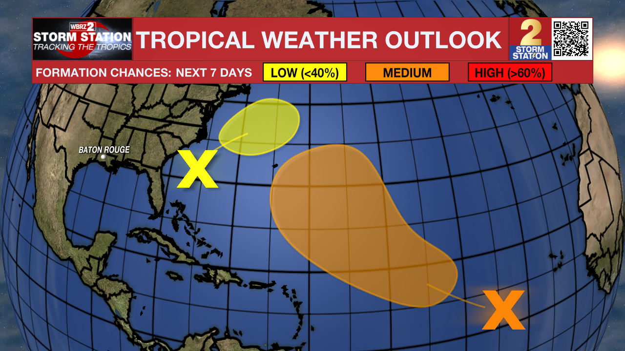
A weak area of low pressure located a few hundred miles off the coast of the southeastern United States is producing minimal shower and thunderstorm activity. Some slow tropical or subtropical development is possible over the weekend and early next week while the system moves northward to northeastward, remaining well off the east coast of the United States.
A tropical wave over the eastern tropical Atlantic is producing a large area of disorganized showers and thunderstorms. Environmental conditions are forecast to be generally conducive for gradual development, and a tropical depression could form over the weekend while the system moves west-northwestward to northwestward across the central tropical and subtropical Atlantic.
Trending News
Get the latest 7-day forecast and real-time weather updates HERE.
Watch live news HERE.
– Emma Kate C.
The Storm Station is here for you, on every platform. Your weather updates can be found on News 2, wbrz.com, and the WBRZ WX App on your Apple or Android device. Follow WBRZ Weather on Facebook and X for even more weather updates while you are on the go.
More News
