

Latest Weather Blog
UPDATE: High Wind Warning on Mardi Gras, strong storms a possibility
High winds and storms on Mardi Gras Day may interrupt some outdoor activities. Have a way to receive weather alerts on Fat Tuesday as the impactful weather arrives in the Capital Region.
Tonight: During the evening and for the first part of the overnight stretch, only a few clouds will be in the region. But clouds will increase late ahead of the Capital Area’s next storm system. Any degree of clearing overnight will allow temperatures to dip into the 50s for a few hours before climbing to near 60° by daybreak. Winds will slowly accelerate through the night, eventually become southeasterly at 10-15 mph.
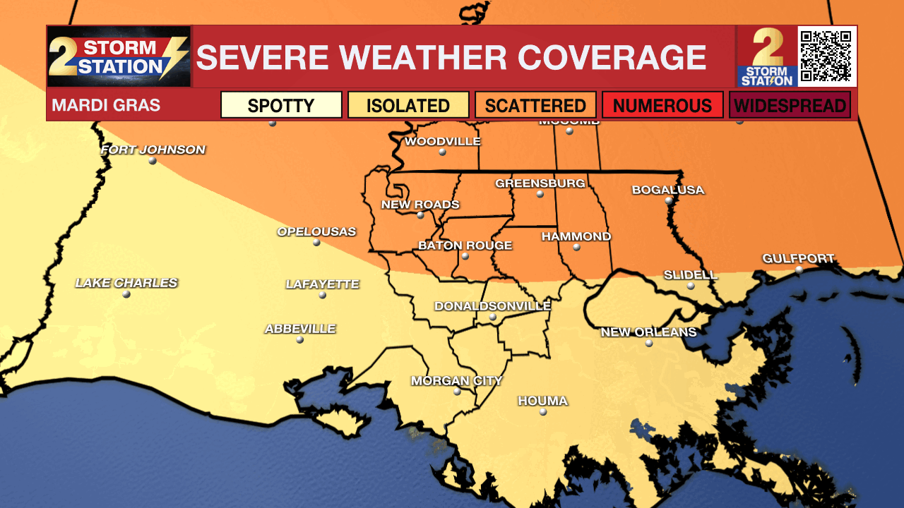
Mardi Gras – Next Impact: The two big weather stories on Mardi Gras will be wind and storms. Gusty winds will be felt by everyone, even outside of thunderstorms. Most will also experience storms during the afternoon, a few of which could be strong to severe.
High Wind – Winds will continue to accelerate on Mardi Gras. A High Wind Warning has been issued across all of southern Louisiana. This alert is not as common, with the Capital Area averaging less than one per year. This emphasizes how much confidence there is in how much wind will be in the area. Sustained winds of 20 to 35 mph are likely with gusts to 45 mph. A few locations might see gusts as high as 60 mph, even outside of thunderstorms.

High-profile vehicles, including Mardi Gras floats, could become unstable if a gust of wind is caught. Travel for these vehicles will also be challenging. Damaging winds may blow down weak or dead trees, leading to scattered power outages.
Storms - Spotty morning showers will turn into widespread showers and thunderstorms during the afternoon. Storms will be in the Baton Rouge metro anywhere between Noon and 6 p.m., with the most likely arrival time in the early to mid-afternoon. These will pose problems for afternoon Mardi Gras parades. Morning festivities will have the best chance of avoiding these issues. In addition, the afternoon storms could be on the strong to severe side. An “Enhanced” Level (3/5) risk of severe weather has been issued for areas north of I-12, with a “Slight” Level (2/5) risk for areas south. While not everybody will experience severe weather, isolated point locations could – especially north of the interstate. All severe hazards (wind, hail, tornadoes) are on the table.
Trending News
Mardi Gras will be a day to stay weather-aware by having multiple ways of receiving weather alerts. One great way to be alerted immediately when severe weather threatens your neighborhood is the Storm Station Mobile App found HERE. Make sure notifications are turned on.
Rest of the Week: Conditions will quickly improve behind a cold front Tuesday night. Expect to wake up to clear skies Wednesday morning. The forecast will remain quiet and mild for Ash Wednesday activities and the second half of the workweek. The next rainmaker is set to arrive in the Capital Area over the weekend.
Get the latest 7-day forecast and real-time weather updates HERE.
Watch live news HERE.
– The Storm Station Meteorologists
The Storm Station is here for you, on every platform. Your weather updates can be found on News 2, wbrz.com, and the WBRZ WX App on your Apple or Android device. Follow WBRZ Weather on Facebook and X for even more weather updates while you are on the go.
More News
