

Latest Weather Blog
LATEST: EXTREME COLD WARNING to take effect as precipitation ends across Capital Area
As precipitation ends across the Capital Area, temperatures will stall in the low to mid 30s. Some drying of surface streets and bridges is expected, but patchy ice remains possible as a hard freeze sets in overnight Sunday into Monday.
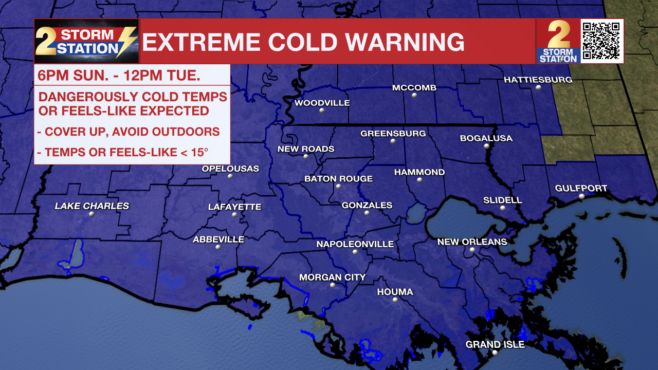
An ***EXTREME COLD WARNING***will go into effect at 6pm Sunday and last until 12pm Tuesday for all of southeast Louisiana and southwest Mississippi. Dangerously cold wind chills as low as 4°F are expected. Frostbite and hypothermia will occur if unprotected skin is exposed to these temperatures. An extended period of freezing temperatures could cause ruptured water pipes.
HOW WIND CHILL WORKS - INSIDE THE WEATHER WITH WBRZ CHIEF METEOROLOGIST, DR. JOSH EACHUS
Dress in layers including a hat, face mask, and gloves if you must go outside. To prevent water pipes from freezing; wrap or drain or allow them to drip slowly. Keep pets indoors as much as possible. Make sure outdoor animals have a warm, dry shelter, food, and unfrozen water. Make frequent checks on older family, friends, and neighbors. Ensure portable heaters are used correctly. Do not use generators or grills inside. If you do not have heat in your home or lack shelter, you can call 211 for assistance locating appropriate shelter from the cold. Use caution while traveling outside. Wear appropriate clothing, a hat, and gloves.
Trending News

Rest of Sunday: Measurable precipitation will end from west to east through the afternoon. Some drizzle or even snow flurries will be possible through early evening. Clouds will be persistent and so will temperatures ranging from freezing near the state line to the upper 30s near the coast. Expect a biting north breeze of 10-15mph causing feels-like temperatures in the low 20s and upper teens. Given these conditions, drying of surface streets and bridges will range from 4-6 hours respectively, a close call for full drying before temperatures go below freezing this evening and patchy ice can develop. Follow the freeze line with us, by tracking the temperatures in the maps section of the Storm Station App. Any depressions and low spots could hold water, which will then turn into ice overnight.
Up Next: The cold will tighten its grip on Sunday night. North winds of 10-20 mph will send wind chills, or feels-like temperatures, plummeting into the single digits and teens by Monday morning. While some sun will come out for the afternoon, most locations will stay in the 30s through the day. By Tuesday morning, air temperatures will fall back into the upper teens, but fortunately, wind will not create a much lower feels-like temperature. With another afternoon of sun, thermometers will break into the 40s. Temperatures will remain chilly through midweek, though the heart of the cold will be on its way out by then.
Get the latest 7-day forecast and real-time weather updates HERE.
Watch live news HERE.
The Storm Station is here for you, on every platform. Your weather updates can be found on News 2, wbrz.com, and the WBRZ WX App on your Apple or Android device. Follow WBRZ Weather on Facebook and X for even more weather updates while you are on the go.
More News
