

Latest Weather Blog
Tuesday AM Forecast: From Scorching to Soaked, Another Weather Shift on the Way
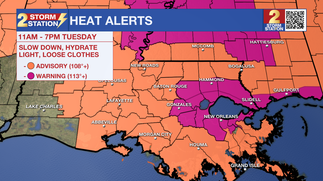
An Extreme Heat Warning will be in effect from 11 a.m. to 7 p.m. Tuesday for Ascension, Livingston, St. James, and southern Tangipahoa Parishes. These areas are generally closer to bodies of water such as lakes and bayous, which will add more humidity to the air. It is in these locations where the heat index could surpass the warning criteria of 113°. A Heat Advisory will be in effect elsewhere, with the heat index peaking near 110°. Such a mixture of heat and humidity could lead to heat-related illnesses, especially without proper hydration. These alerts serve as a reminder to drink plenty of fluids and take it easy during the hottest parts of the day.
Today & Tonight: Sunny skies early will push temperatures into the mid-to-upper 90s again this afternoon. With the added humidity, it will feel more like 110–115° in some areas, prompting another round of heat alerts (see above). While heat will be the main story again today, changes are on the way. Tropical moisture moving in late in the day will bring a few spotty storms by late afternoon and evening. Some storms may linger after dark, thanks to the continued moisture, even though storms usually die down at night during summer. Watch out for another batch of isolated t-showers early Wednesday. Temperatures overnight will fall to near average for the end of July, into the mid-70s.
Up Next: With plenty of moisture in the air and an upper-level disturbance moving through, scattered showers and storms are possible throughout the day on Wednesday—from morning to evening. While there will be breaks of sunshine and dry time, it’s a good idea to keep an umbrella handy in case storms pop up, especially if you plan to attend WBRZ's Stuff The Bust tomorrow!
Rain chances will stay elevated through the start of the weekend as deep tropical moisture lingers. Most storms will be hit-or-miss and mainly in the afternoon. Despite the clouds and rain, highs should still reach the mid-90s each day, thanks to some early sunshine.
Over the next 7 days, most areas can expect around 1 to 3 inches of rain. That should be manageable overall, though some neighborhoods may see minor street or drainage flooding at times. Looking ahead, a weak front could settle near or just north of the area by late weekend, potentially shifting the heavier moisture south and lowering rain chances across the Metro; this will be something to monitor over the next several days as more data becomes available. Keep checking in with the Storm Station for the latest!
The Tropics: No tropical development is expected in the next seven days across the North Atlantic, Caribbean Sea, and Gulf.
Trending News
Get the latest 7-day forecast and real-time weather updates HERE.
Watch live news HERE.
— Emma Kate C.
The Storm Station is here for you, on every platform. Your weather updates can be found on News 2, wbrz.com, and the WBRZ WX App on your Apple or Android device. Follow WBRZ Weather on Facebook and X for even more weather updates while you are on the go.
More News
