

Latest Weather Blog
Thursday AM Forecast: Cooler end to week ahead of weekend storms
Chilly mornings and mild afternoons take over to end the workweek. Those with Valentine's Day plans or heading out to Alex Box Stadium for Opening Day may dodge a spotty shower or two, but the next major rainmaker will arrive Saturday night.
Today & Tonight: Behind a cold front that brought rain and storms Wednesday evening, drier and cool air will continue to filter in Thursday morning. Lows will be noticeably chillier, in the upper-40s, with highs today only warming into the low to mid-60s. Any clouds around during the morning commute will quickly clear and give way to a mostly sunny day. Winds remain breezy Thursday, out of the north, between 10-20mph and gusting higher at times. Overnight, expect some of the coolest air since late January as temperatures fall into the lower 40s by Friday morning.
Friday: After a chilly morning, clouds will begin to increase throughout the day Friday. Mostly clouds skies will take over by Friday afternoon and a spotty shower or two may be able to squeeze out of them at times. Afternoon highs will be in the mid-60s and those with Valentine's dinner plans should expect temperatures in the upper-50s by 7pm.
Saturday: To start the weekend, expect warm and breezy conditions, with temperatures soaring into the low to mid-80s—possibly near record highs. Winds will be breezy out of the south at 15-25mph, with gusts up to 35 mph at times. A stubborn cold front to our northwest will finally get a strong push south late in the day and overnight, bringing rain and the risk of severe thunderstorms as this happens (see below).
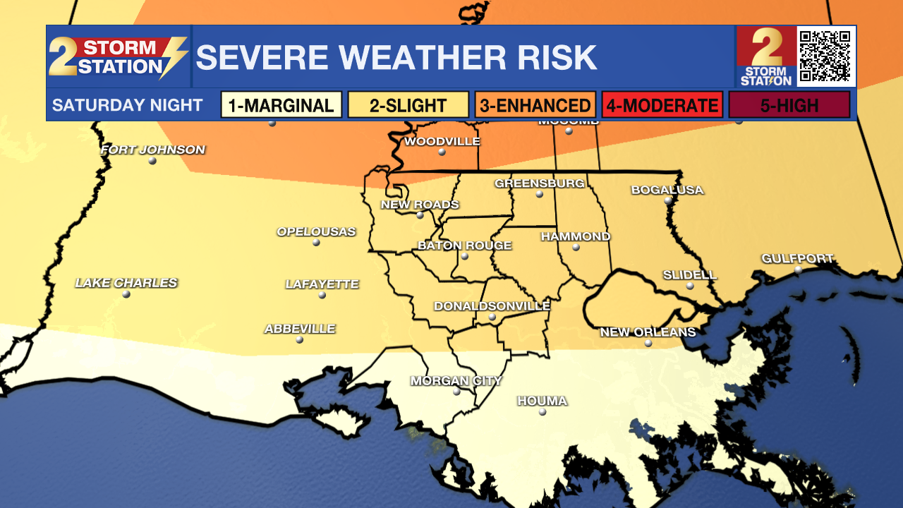
Next Severe Weather Chance – On Saturday, there is support for a strong upper-level disturbance swinging through the region. If it takes the right track, most ingredients would be in place to support severe thunderstorms development in or near our area. As of Thursday morning, the Storm Prediction Center has included the majority of southeast Louisiana in a slight (2/5) threat for severe weather Saturday night, with an increased, enhanced (3/5) risk along and north of the Mississippi state line. Details should come into focus later today and Friday as the responsible disturbance moves over the West Coast.
Sunday & Beyond: The cold front will clear out early Sunday, leading to sunny and much cooler weather. Highs will only reach the 60s on Sunday before lows bottom out near freezing on Monday morning. Temperatures will remain a few degrees below average into Tuesday before our next rainmaker arrives towards the middle of next week.
Trending News
Get the latest 7-day forecast and real-time weather updates HERE.
Watch live news HERE.
– Emma Kate C.
The Storm Station is here for you, on every platform. Your weather updates can be found on News 2, wbrz.com, and the WBRZ WX App on your Apple or Android device. Follow WBRZ Weather on Facebook and X for even more weather updates while you are on the go.
More News
