

Latest Weather Blog
UPDATE: Line of storms approaching from the west, Tornado Watch remains in place
UPDATE - 6:30 p.m. Wednesday: As showers and thunderstorms press into the Metro Area, activity has remained beneath severe limits. Earlier rain helped to stabilize the atmosphere, robbing the main like of the bulk of the available storm energy. Elsewhere, in more favorable conditions, tornadoes have already occurred across southern Mississippi.
The main line of showers and thunderstorms will move east of I-55 and the Storm Station Forecast Area around 10pm Wednesday. Until then, damaging winds and embedded spin-up tornadoes remain possible but the severe weather threat has been rapidly decreasing from west to east with time. You can view the latest radar loop below.

A *TORNADO WATCH* remain in effect for East Baton Rouge, West Baton Rouge, Ascension, Assumption, Iberville, East Feliciana, Livingston, Pointe Coupee, St. Helena, St. James, St. Mary, Tangipahoa, and West Feliciana Parishes, as well as Amite and Wilkinson Counties until 8 p.m. Wednesday.
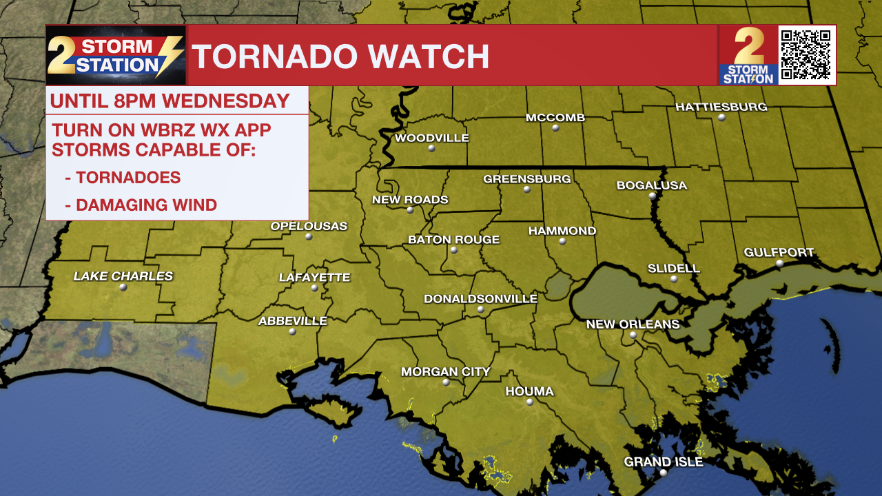
A TORNADO WATCH means conditions are favorable for tornadoes and/or damaging winds in and around the watch area. Be on the lookout for threatening weather conditions and listen for later statements and possible warnings. If a Tornado Warning is issued, seek shelter in a low-level, interior room of a sturdy building. Take pets (on a leash) with you, have on hard-soled shoes, monitor storm coverage on a wireless device, and cover your head in the event of wind or tornado impact. For more on tornado safety, CLICK HERE.
Tonight & Tomorrow: Between 5-9 p.m., a cold front will drive a line of storms through the Capital Area. These too could be capable of damaging winds and brief spin-ups, although the hail threat would lessen after dark. By 10-11 p.m., the cold front will begin pushing the rain out. There will not be an overnight severe weather threat. In fact, skies will show signs of partial clearing by Thursday morning. Cooler air will also rush into the region. Expect a mixture of clouds and sun for the rest of Thursday with a more seasonably high in the mid-60s.
Trending News
Remember that the WBRZ WX App. is *free* on Apple and Android devices and can be used for breaking weather information, live radar, and forecast details. You can also use it to watch live coverage if power or broadcast signal is ever lost. For even more, connect with the Storm Station on Twitter and Facebook. Stream WBRZ+ for continuous information as it becomes available.
Click HERE to watch WBRZ streaming live online
Click HERE for the WBRZ weather page.
Click HERE to see how to download the WBRZ weather app.
Valentine's Day: Temperatures will remain relatively cooler on Valentine's Day, but still close to normal for the time of year with highs in the mid-60s. Though the low levels will be dry, and rain is not expected, moisture in the upper levels will keep some clouds around. That moisture will get pushed over the stalled front leading to increasing clouds and spotty showers.
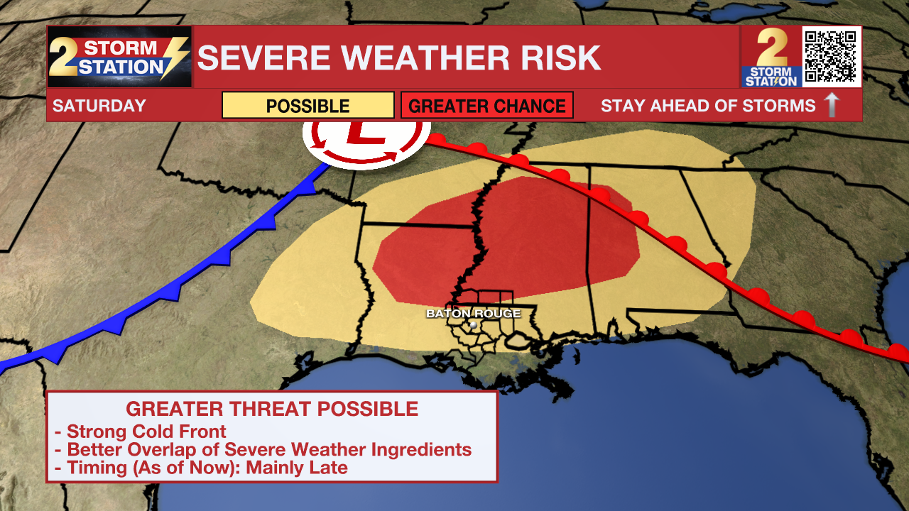
Saturday & Beyond: To start the weekend, expect warm and breezy conditions, with temperatures soaring into the low to mid-80s—possibly near record highs. Winds out of the south at 15-25 mph will be noticeable, with gusts up to 35 mph at times. The stubborn front will finally get a strong push south late in the day and overnight, bringing rain and the risk of severe thunderstorms as this happens (see below). The cold front will clear out early Sunday, leading to sunny and much cooler weather. Highs will only reach the 60s on Sunday before lows bottom out near freezing on Monday morning. Temperatures will remain a few degrees below average into Tuesday.
Another Severe Threat on Saturday: Being several days out, there are still a lot of unknowns with how everything plays out on Saturday. There is support for a rather potent upper-level disturbance swinging through the region. If it takes the right track, most variables would be in place for what could be a bigger severe weather threat. The Storm Prediction Center highlights much of the area as having the potential for severe weather on Saturday. In fact, confidence is growing in a severe weather event north of Baton Rouge, into Mississippi. Details should come into focus later in the week as the responsible disturbance moves over the West Coast.
All told, 1-3” of rain is expected in the next week. The fast-moving nature of the rounds of rain should prevent widespread flooding issues.
Get the latest 7-day forecast and real-time weather updates HERE.
Watch live news HERE.
– Storm Station Team
The Storm Station is here for you, on every platform. Your weather updates can be found on News 2, wbrz.com, and the WBRZ WX App on your Apple or Android device. Follow WBRZ Weather on Facebook and X for even more weather updates while you are on the go.
More News
